
The Delta-X JPL and UNC ADCP teams returned to the Mississippi Delta on Monday, 20 September to retrieve water level gauges. They plan to stay until Sunday, 26 September. The Boston University Water Quality team has been collecting data over the past week and plans to return on Friday, 24 September. Water Quality team members on an airboat operating a Portable SpectroRadiometer (PSR) that measures above-water surface reflectance, an in-situ field measurement analogous to the imagery that AVIRIS-NG produces.
You are here
News
09/23/2021
The L-band radar aboard the Armstrong C-20A jet successfully completed the Delta-X fall campaign on 7 September. In all we conducted 7 flights, imaging Atchafalaya Basin, East and West Terrebonne Basin in high tide and receding tide. We were co-flying with AirSWOT aboard the Dynamic Aviation B-200 based at Port Arthur, TX. Data have already been returned to JPL and processing is well underway.
During the Delta-X deployment, we managed to acquire post-Hurricane Ida data over the City of New Orleans on 31 August and the severely affected area just east and south of Terrebonne Basin on several flights. It was a great opportunity to leverage Delta-X campaign to support disaster response and management. As it turns out the most useful data we were able to provide for this event were the oil slick images just south of Port Fourchon, where many oil rigs were damaged by the hurricane. An example of UAVSAR’s oil slick detection is showcased in a JPL Press Release:
https://www.jpl.nasa.gov/news/nasas-delta-x-helps-with-disaster-response-in-wake-of-hurricane-ida
In addition, we worked with NOAA Satellite and Information Service (NESDIS) to develop a protocol for generating Marine Pollution Surveillance Report (MPSR) for future oil spill response events.
09/16/2021
Delta-X had 2 AirSWOT and UAVSAR co-flights during the last week over Terrebonne West and Atchafalaya high tides. The fall campaign radar science flights are considered complete as of Monday morning at 12:21 AM CDT, just as tropical storm (may become H-1) Nicholas approaches the coast of Southeast Texas. Ida, and now Nicholas, remind us of the importance of Delta-X science and what can be achieved with the new data. In all, AirSWOT flew 11 science flights (203 science lines) and UAVSAR flew 7 science flights (95 Delta-X lines) during the fall campaign. Attached is a short clip of AirSWOT and UAVSAR flying together.
09/07/2021
The JPL QUAKES team collected SWIR imagery of the Caldor fire in California in a flight with UAVSAR in the ASFC Gulf Stream.
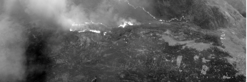
Panoramic view of a portion of the Caldor flight (roughly 30 seconds).
The SWIR camera is able to view through much of the smoke so that
hot spots can be found (a comparable visible image is entirely obscured by smoke).
09/07/2021
For the Delta-X campaign, AVIRIS-NG flew on 24 and 25 August over Terrebonne basin and completed all required flight lines. The ground teams also took as much measurements as possible before hurricane Ida made landfall on 29 August. UAVSAR and AirSWOT resumed flights on Wednesday, 1 September over Terrebonne East. AVIRIS-NG will resume flights on 14 September for approximately 10 days in order to provide before and after images from the hurricane damage.
08/25/2021
The Delta-X fall campaign is well underway. The fall campaign is meant to capture the hydrodynamics and vegetation patterns of the region while the Mississippi River discharge is near its lowest point and when vegetation has reached its peak biomass. Delta-X already captured the highest annual river discharge when herbaceous vegetation is just starting to grow in the Spring.
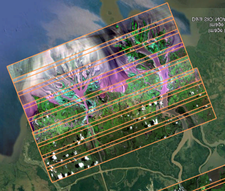
AVIRIS-NG flew 4 flights over the last week, starting on August 18th, and completed Atchafalaya vegetation and water quality lines. It also flew Terrebonne vegetation and water quality lines, nearly completing the Terrebonne West vegetation lines. Image below shows quick look image of AVIRIS-NG lines over Wax Lake Delta in the Atchafalaya basin.
AirSWOT also flew 4 flights: over Atchafalaya high & receding tide and Terrebonne East & West high tide to measure water surface elevation.
Together, AirSWOT and AVIRIS-NG flew 3 joint flights. UAVSAR is scheduled to join the campaign on Saturday August 28th flying on the ARFC G-III.
Field teams and have been taking measurements on the ground coincident with the airborne instruments as much as possible. Water Quality (Boston University) team collected water samples as well as reflectance to coincide with AVIRIS-NG overflight. The Islands Team (Caltech and University of Texas) collected depth profiles, sediment profiles, as well as water samples and ADCP transects (i.e. river discharge measurements) to complement data collected by the ADCP (JPL and University of North Carolina) and Water Quality teams.
The Vegetation Team (Florida International University) collected vegetation samples (pictured below), root and soil cores, and characterized subplot representativeness.
07/01/2021
The L-band radar aboard the AFRC C-20A successfully completed all 7 local California flights for monitoring Central San Andreas Fault, Hayward Fault, and the Eel River landslide study. The Eel River landslide is a joint study with the P-band radar to determine the relative sensitivity of landslide detection between the two frequencies in vegetated area. Despite the pandemic, we have flown 290 flight hours in FY21 and is slated to fly about 500 hours by the end of FY21.
06/24/2021
The JPL QUAKES team is conducting the first flight test of the QUAKES-I instrument over Southern California. The flight plan covers the highest and lowest points in California, earthquake faults in the state’s interior and some coastal zones. The visible imagery collected by the instrument will be processed into a geo-rectified 3D terrain map and point cloud for use in understanding plate tectonics and other surface phenomenon.
05/27/2021
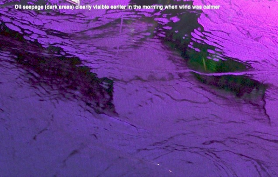
The L-band radar aboard the JSC G-III successfully completed the Santa Barbara Oil Slick experiment on 14 May in support of a NASA ROSES grant from NASA’s Earth Science Disasters program, managed by David Green, to develop an algorithm to measure oil slick thickness using SAR to become Operational at the NOAA Marine Pollution Response group. The purpose of this campaign is to validate oil slick characterization algorithms and to prepare for NISAR disaster response to oil spills and major storms. The study site is a natural seep field off the coast of Santa Barbara, CA. UAVSAR observations will be integrated with in-situ data and satellite imagery in the analysis. The two UAVSAR polarimetric color composite images acquired two hours apart show the evolution of the oil thickness with respect to increasing wind speed as seen in radar backscatter. Oil on the sea surface effectively smooths the ocean surface and reduces the radar backscatter compared to the surrounding ocean. As the sea surface was roughed up by increasing wind speed, only the thicker oil slick remained visible in radar backscatter imagery. JPL participation on the study included Ben Holt (329), who was on the vessel, and Cathleen Jones (334) who was onboard during the UAVSAR overflights.

05/13/2021
The JPL QUAKES SAR Fusion imagery collected during transit from Houston to Southern California. The SAR Fusion suite of sensors includes 2 SWIR and 2 visible Bayer imagers that are coincident with the SAR sensor.
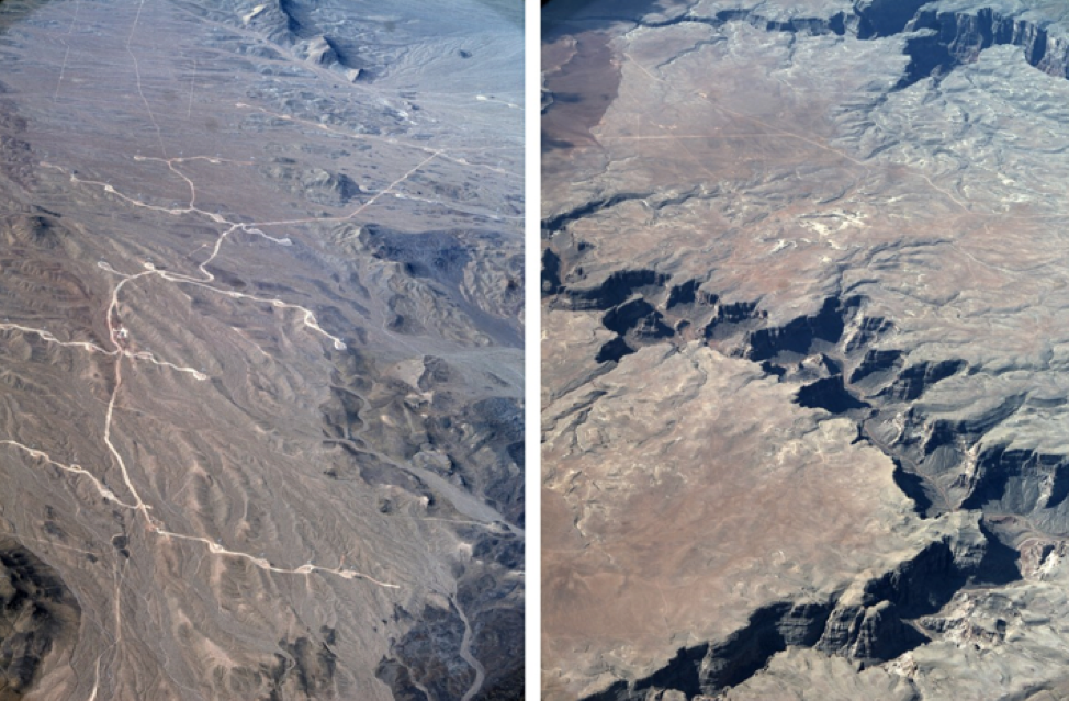
Images collected over high relief areas. The team is getting the
data off the plane this week and will process them into 3D products