
The Next Generation Airborne Visible and Infrared Imaging Spectrometer (AVIRIS-NG) is currently collecting data for the CA Methane Survey.
You are here
News
09/15/2017
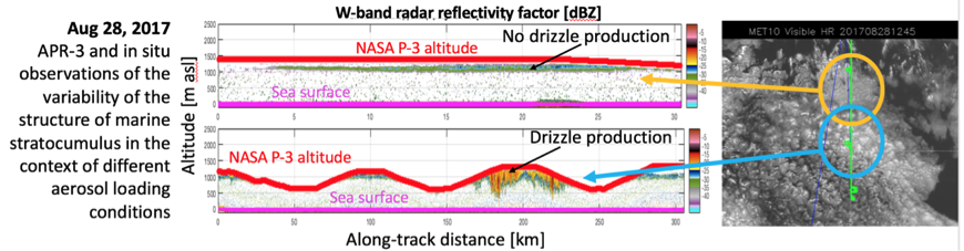
The Airborne Precipitation and Cloud Radar 3rd Gen (APR-3) successfully completed the 2017 deployment onboard the NASA P-3 for the ORACLES EV-S mission.
The Observations of Aerosols above Clouds and their Interactions Mission completed the second of three, one-month long deployments to probe how smoke particles from massive biomass burning in Africa influences cloud cover over the Atlantic. Particles from this seasonal burning that are lofted into the mid-troposphere and transported westward over the southeast Atlantic interact with permanent stratocumulus "climate radiators," which are critical to the regional and global climate system. The 2017 ORACLES deployment was based on Sao Tome with one suitcase deployment to Ascension Island.
APR-3 provides Doppler radar measurements of clouds and precipitation at 3 frequencies (Ku-, Ka- and W-band). APR-3 was developed at JPL under ESTO AITT’12 program by merging the Airborne Precipitation Radar 2nd Generation (APR-2, Ku and Ka band) with the Airborne Cloud Radar (ACR, W-band) and it is operated on the NASA P-3 for the ORACLES Mission by a joint JPL – University of Wisconsin team. APR-3 acquired observations of the structure and dynamics of marine boundary layer clouds at unprecedented resolution in all of the successful science flights of ORACLES 2017. APR-3 experienced a significant hardware issue on the W-band computer during the outgoing transit flight, but the issue was promptly resolved by the field team as soon as the P-3 reached the base of operations in Sao Tome. The affected subsystem was replaced by a full spare that had been pre-deployed via air shipment. The repairs did not cause any delay on the Mission flight schedule, and the new subsystem performed flawlessly for the rest of the campaign.
Compared to the ORACLES 2016 deployment, this year a significantly larger body of work was focused on a variety of cloud types, and this resulted in the acquisition of extremely intriguing observations that will be analyzed in the next two years. Again, compared to 2016, a larger fraction of the radar profiles includes echoes from the Ka- and Ku-band precipitation channels, and more modules were performed where radar observations were backed within 10s of minutes by in situ acquisitions of microphysical cloud and precipitation properties: these observations will be critical for the development of improved algorithms for current and future cloud and precipitation radar observations from space. By the same token, the synergy with HSRL (lidar), RSP (polarimeter) and radiometers was exploited to a greater extent in regards to cloud retrievals in this 2017 deployment. The processing code to produce preliminary geolocation and calibration for the basic L2 products (radar reflectivity and mean Doppler velocity) developed during the winter of 2016/17 was successfully exercised to produce quicklooks (when necessary also in quasi-real time in flight) and new experimental algorithms to provide more advanced analysis products requested by the Science Team was developed and successfully tested on in field data.
APR-3 also acquired data useful to GPM, ACE, and SWOT during the transatlantic legs between Wallops and Ascension Island. They include observation of cloud formations in the ITCZ possibly enhanced by the outflow of Hurricane Irma, and three frequency observations of marine cumulus congestus that are relevant to the recently concluded CPEX experiment as well as the planned CAMP2Ex campaign (Philippines, 2018).
09/07/2017
Last week the L-band Synthetic Aperture Radar aboard the NASA 502 aircraft was tasked to support Hurricane Harvey flood response in southeast Texas. It arrived in Austin on Wednesday, 30 August and four daily flights were conducted over the major flood zones in the greater Houston area as well as east Texas along the Neches River through Beaumont and Port Arthur and the Sabine River.
Quick-look processing was performed on the aircraft as well as in the hotel post-landing in order to shorten the data delivery latency to the State of Texas emergency response agencies led by flood response experts from University of Texas Center for Space Research. All the quick look products were delivered within 3 hours after each radar flight and UAVSAR data are used to identify levee breach and levee over tops (water flowing over the levees) around small towns and neighborhoods, flooding in refineries, especially containment breach and over tops around the oil tank batteries. UAVSAR data are also used to identify where the “dry spot” is for disaster relief folks to stage relief centers near Beaumont.
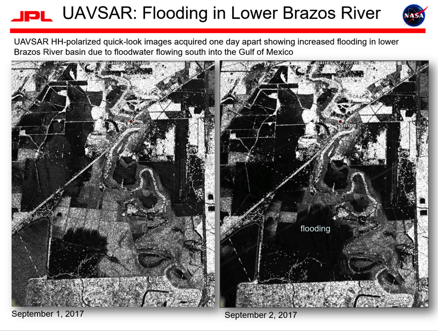
UAVSAR images acquired one day apart showing increased flooding in the
lower Brazos River basin due to floodwater flowing south into the Gulf of Mexico.
08/31/2017
The Next Generation Airborne Visible and Infrared Imaging Spectrometer (AVIRIS-NG) departed Canada on the King Air B200 on 26 August. The flight crew completed NASA funded Methane collections in Alberta. The aircraft transited through the Pacific Northwest and remained overnight (RON) on 26-27 August in Portland, OR and collected Methane targets in the region.
08/31/2017
After one of the biggest recorded snowpacks in California history, ASO finally completed its 2017 snow survey season in cooperation with the California Department of Water Resources last weekend. The ASO compute and science team is finishing the data processing and analysis of the August snow surveys; final deliveries are expected to be made by early September.
08/24/2017
On 14 August, ASO surveyed the Ranch and Sayre fire sites in northern Los Angeles County in support of the Chlorophyll Fluorescence Imaging Spectrometer (CFIS) project, successfully completing a total of 37 flight lines.
08/24/2017
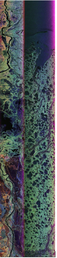
The P-band Synthetic Aperture Radar aboard the JSC G-III has successfully completed 7 of 9 science flights in support of the summer 2017 ABoVE (Arctic-Boreal Vulnerability Experiment) Airborne Campaign in Canada and Alaska. Last Wednesday (9 August), we imaged the tundra and boreal forest near and around Great Slave Lake in Northwest Territories, Canada before transiting to Fairbanks on Thursday (10 August), where we imaged the boreal forest in Yukon Territory, Canada and long-term study sites in Delta Junction just southeast of Fairbanks. On Sunday (13 August), we imaged permafrost near Prudhoe Bay and Barrow in North Slope as well as Seward Peninsula. On Monday (14 August), our focus area was Southwest Alaska, where we imaged Yukon Delta National Wildlife Refuge, Katmai National Park and Preserve, and one transect across Lake Clark National Park and Preserve. On Tuesday (15 August), we conducted a TomoSAR experiment over Delta Junction, in which multiple passes over the target area were acquired with tightly controlled separation between the flight tracks, enabling three-dimensional tomographic imaging of forest structure.
Attached are two color composite quick look images where red, green, blue represent HH, HV, VV polarization channels respectively. The first quick look image is data acquired on 8 August over Peace-Athabasca Delta showing the complex biome in the delta region with Athabasca River to the south and Slave River to the north. The second quick look image is data acquired on 13 August over permafrost near the Beaufort.
Sea shoreline in North Slope, covering three CALM (Circumpolar Active Layer Monitoring) locations west of Colville River where active layer depths and permafrost have been monitored for decades.
08/24/2017
The Next Generation Airborne Visible and Infrared Imaging Spectrometer (AVIRIS-NG) has been finishing up collections for ABoVE in Canada. They will complete data collections in Saskatoon this week, and Friday will be the last day for ABoVE flights.
08/10/2017
The P-band Synthetic Aperture Radar aboard the JSC G-III has embarked on the second half of the 2017 ABoVE (Arctic-Boreal Vulnerability Experiment) Airborne Campaign in Canada/Alaska. Data was acquired over AirSWOT flight tracks near Saskatoon and boreal forest over the BERMS site, imaged large transects of boreal forest in eastern Alberta, as well as Fort Resolution, the mouth of Slave River at the southern shore of Great Slave Lake.
08/10/2017
The Next Generation Airborne Visible and Infrared Imaging Spectrometer (AVIRIS-NG) is flying on the Dynamic Aviation King Air for the NASA ABoVE Campaign. AVIRIS-NG is flying in Northwest Territories this week, and last week went as far North as Cambridge Bay. Flights will continue for the next few weeks.