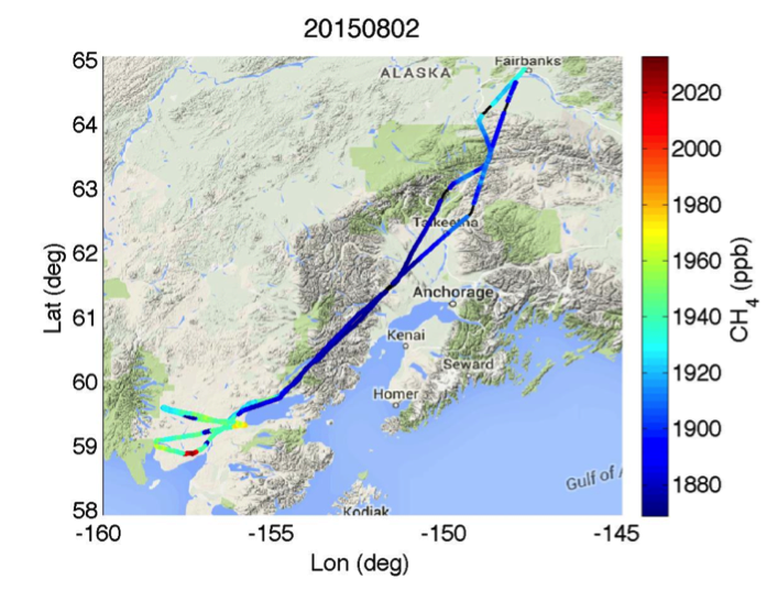
On Sunday 2 August, CARVE flew a 7 hour science flight over Dillingham, Alaska.
CARVE observed enhanced CH4 in the Dillingham area.

On Sunday 2 August, CARVE flew a 7 hour science flight over Dillingham, Alaska.
CARVE observed enhanced CH4 in the Dillingham area.
OMG's Bathymetry sonar survey is progressing nicely. Below is a summary report from 1 August. Ship has surveyed 749 NM, in 9.1 days, with 79 CTD casts (Conductivity, Temperature and Depth profiles)


Airborne Snow Observatory was featured in Bloomberg.com this week. The article can be accessed via http://www.bloomberg.com/news/articles/2015-07-06/how-nasa-s-flying-laboratory-is-tracking-california-s-drought
CARVE flew 23 flight hours, collecting science data from the North Slope, Seward peninsula and Dillingham / King Salmon, Alaska.
On July 11, CARVE flew Over Dillingham / King Salmon and collected the following data (this was CARVE's first time collecting data over this area).
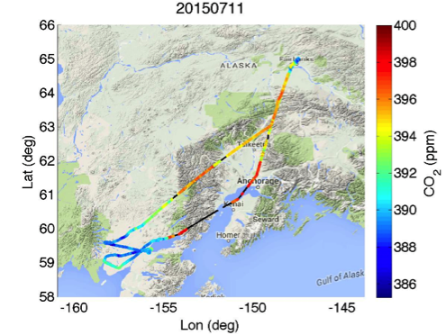
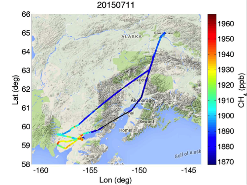
The above plots show reduced CO2 and enhanced CH4 signals.
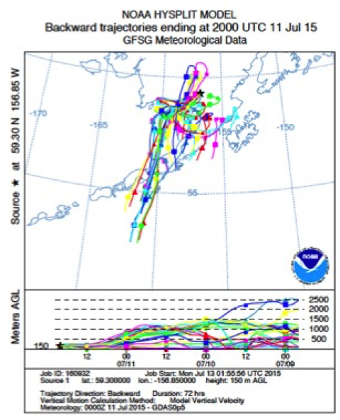
The HYSPLIT 72-hour back trajectories model, suggest that the near surface air masses observed near Dillingham on July 11 had circulated in the area for 24 to 48 hours after coming in off the Gulf of Alaska.
MASC was successfully integrated on the NASA DC-8 as a piggyback payload on the Plains Elevated Convection at Night (PECAN) campaign. The operators were able to record MASC data during the transit flight from Palmdale to Kansas in addition to 6 hours of data from first science PECAN flight.
A partial set of data can be seen at:
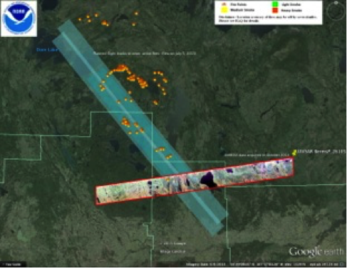
The P-band radar onboard the JSC G-III was deployed in Saskatoon, Canada for the boreal forest observation (first of three observations this year). Our study site is at the southern end of a number of large wildfires raging in Saskatchewan, Canada. We were able to add two flight lines to our last (of three) flights to image the wildfire scars on July 5, 2015 (see graphic). The raw data are being returned to JPL for processing. Our pilot-in-command for the deployment, Tom Ryan, was interviewed on CBC Radio broadcast in Canada. The Canadians were quite excited about a NASA aircraft studying wildfires in their country (granted it was opportunistic).
This week, CARVE flew a short flight to Lake Minchumina and two flights to the North Slope. (Barrow and Prudhoe Bay)
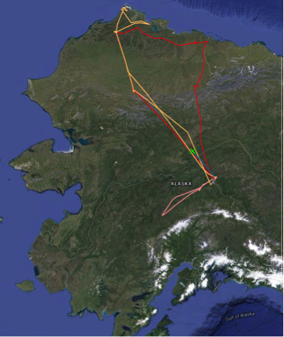
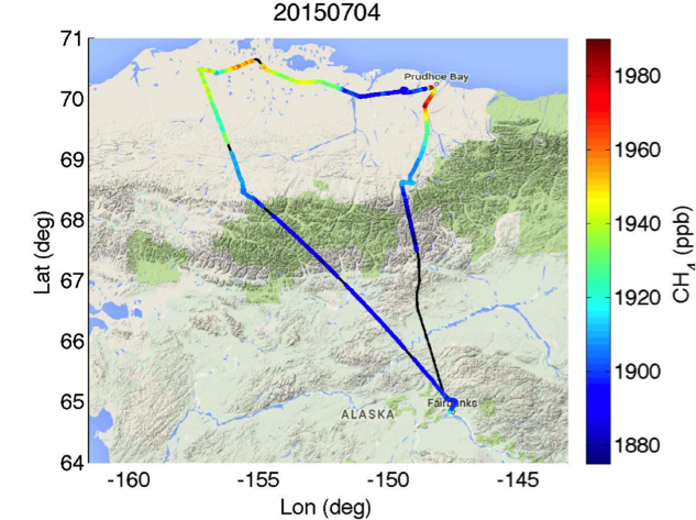
On the Fourth of July, CARVE flew up to Barrow and Prudhoe Bay. CARVE acquired enhanced CH4 South of Barrow and South of Prudhoe Bay.
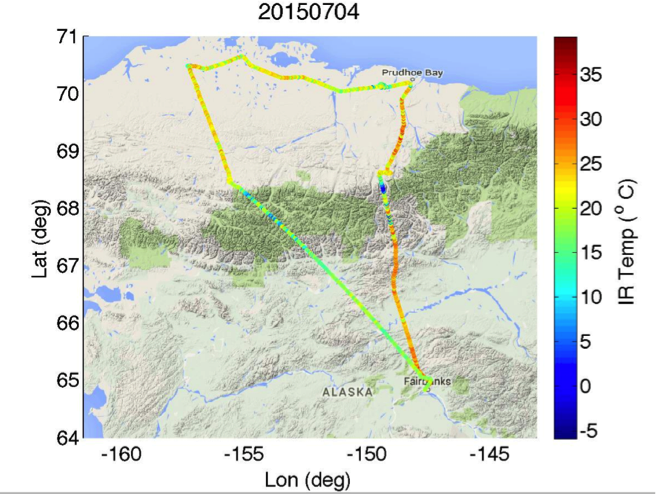
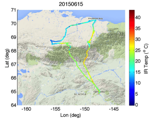
CARVE's IR surface camera indicated spring like temperatures on the North Slope.
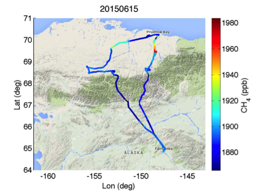
On Monday June 15, CARVE flew its last flight for the June campaign, flying over the North Slope and acquired enhanced CH4 South of Prudhoe Bay.
IR temperature plot for June 15:
Also this week, Thomas Kurosu, presented three years of CARVE FTS observations at the 11th International Workshop on Greenhouse Gas Measurements.
Last week on June 10-11, we completed the third phase of the Europe campaign where we flew three sorties out of Stavanger, Norway, to participate in a Norwegian controlled oil spill test in the North Sea. We acquired L-band polarimetric SAR imagery over small controlled spills of different emulsions to develop and validate a SAR-based capability to accurately measure oil volumetric fraction for future spill response (PI: Cathleen Jones). Building on previous work in the Gulf Coast, we were able to see the boats participating in the exercise and the released oil slicks on the on-board processed imagery, and to adjust the flight lines in real time during the flight to follow the movement of the slicks at sea. The four short radar-dark slicks near the top of the attached image (norway-oil-obp.jpg) are the different emulsion releases from an exercise on June 10, while the longer slicks at the bottom are from a release of a much greater volume of oil that occurred on June 9. The experiment is part of the annual NOFO (the Norwegian Clean Seas Association for Operating Companies) Oil-On-Water exercise to test new spill remediation equipment. This year's international participants include Norway, Finland, France, and the USA. Besides UAVSAR, the French Falcon 20 aircraft operated its airborne SAR (SETHI) in polarimetric X-band and L-band modes and a hyperspectral imager. Participants from Finland operated a SLAR and a SAR onboard its Dornier 280-212 aircraft. In addition, satellite imagery from Radarsat2, TerraSAR-X, PALSAR2, and RISAR were acquired on Wednesday, June 10.

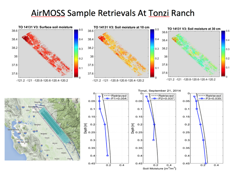
The processing of AirMOSS science data is progressing as planned, with many new L2/3-RZSM and L4-RZSM products being delivered to the LP-DAAC. The attached image tonzi-example.png shows an example of a recent retrieval of soil moisture profile at the Tonzi Ranch site, where the retrieval accuracy is seen to be between 0.035 m3/m3 and 0.054 m3/m3 for different in-situ profiles.