
AirMSPI took part in the Aerosol Characterization from Polarimeter and Lidar (ACEPOL) field campaign, which took place from 19 October to 9 November with the NASA ER-2 high altitude research aircraft flying out of the Armstrong Flight Research Center (ARFC) in Palmdale, CA.
ACEPOL is a collaborative effort among the NASA Aerosol-Cloud-Ecosystems (ACE) pre-formulation study, the Cloud-Aerosol Lidar and Infrared Pathfinder Satellite Observation (CALIPSO) project, and the Netherlands Institute for Space Research (SRON). The objective of ACEPOL is to assess the capabilities of proposed future instruments to answer fundamental science questions associated with aerosols, clouds, air quality, and global ocean ecosystems. ACEPOL also acquired reference data for the ongoing CALIPSO satellite mission. ACEPOL results are relevant to future satellite missions such as joint European Space Agency (ESA) – Japan Aerospace Exploration Agency (JAXA) Japanese Earth Clouds, Aerosol and Radiation Explorer (EarthCARE), the NASA Plankton, Aerosol, Cloud, ocean Ecosystem (PACE) mission, and JPL’s Multi-Angle Imager for Aerosols (MAIA) Earth Ventures Instrument. In particular, data acquired during ACEPOL will be used to assess remote sensing retrievals of aerosol and cloud microphysical and optical parameters and aerosol and cloud layer heights. ACEPOL results will further enable the development of novel aerosol and cloud retrieval algorithms by utilizing the full information content provided by the combination of active and passive remote sensing instruments.
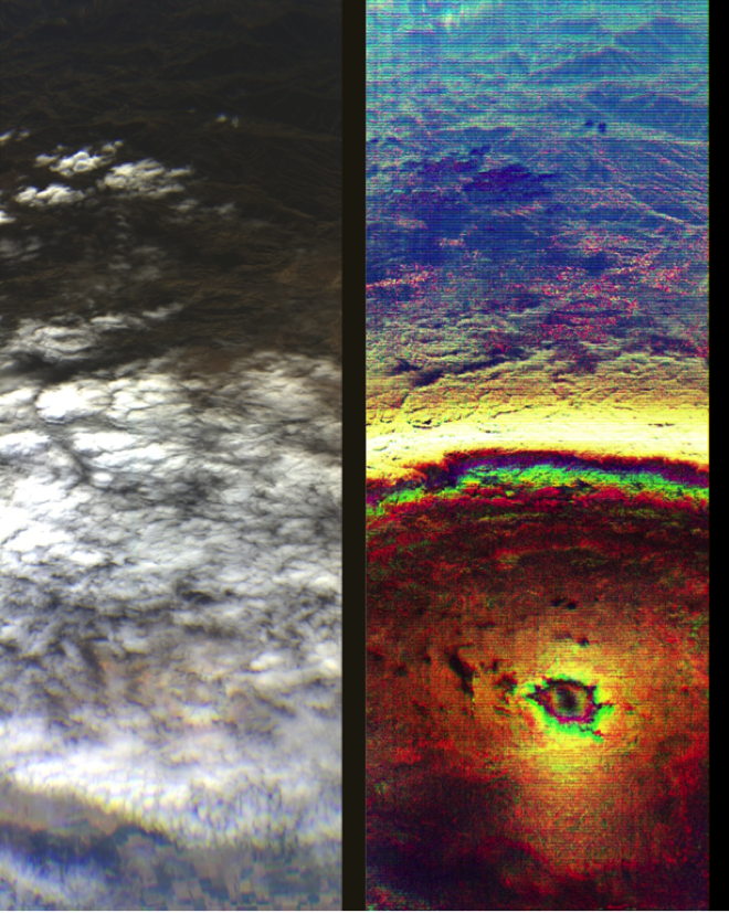
(Left) AirMSPI red/green/blue image of liquid water clouds over land (Right). Same image in degree of linear polarization from the near-infrared/red/blue bands. The small, circular feature is the glory and the larger, bright white arc is the cloudbow. The size, location, and brightness of these features provide information on cloud microphysics.