You are here

News

05/09/2014

The L-band SAR onboard the AFRC C-20 aircraft (NASA 502) has successfully completed the month-long deployment to New Orleans, Panama, Peru, and Chile. Both the aircraft; the L‑band SAR worked extremely well, and the weather was mostly favorable. We successfully completed 19 of the 20 planned science flights over 10 of 11 planned countries for 95.4 total hours; research topics included volcanic deformation, forest structure, soil moisture, glacier motion, and coastal subsidence. We were not able to acquire data in Ecuador because the diplomatic clearance was not provided in time. Preliminary assessment of radar data and DGPS data while on deployment verified that we had good flight path performance and radar stability for repeat-pass interferometry.

We conducted 3 outreach events each in Santiago Chile and Lima, Peru where we visited CONICYT (the Chilean NSF), CONIDA (the Peruvian Space Agency), World Wildlife Foundation (WWF) of Peru, Universidad Tecnologica del Peru, and hosted two tours of the aircraft for Chilean research scientists and high school students. Most of the outreach events were coordinated by US Embassy personnel in Chile and Peru. The visits generated much interest in both countries as imaging radar technology for environmental remote sensing is a relatively new technology in both countries.

05/01/2014

As presented at the recent SEAC4RS Science Meeting (Boulder, Colorado), the newly redesigned JPL Laser Hygrometer (JLH) Mark2 measured enhanced water vapor in the stratosphere due to convective injection over the continental United States. Such convective injections have been suggested to lead to chemical perturbation and ozone depletion in the stratosphere. Enhanced water was measured on five flights of the NASA ER-2 aircraft and observed by Aura MLS (courtesy of Michael Schwartz).

05/01/2014

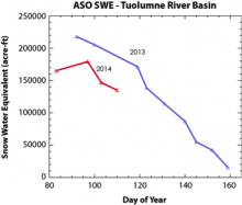
The Airborne Snow Observatory has flown over the Tuolumne River Basin and other local watershed areas (e.g., Merced) 44 times on 12 separate days in the past month. Data was collected using a Riegl LMS Q1560 scanning laser altimeter. Data was collected using a Riegl LMS Q1560 scanning laser altimeter and a ITRES CASI-1500 imaging spectrometer.  Using advanced algorithms developed at JPL, the snow water equivalent (SWE) in the area has been determined and plotted against last year’s SWE in the same area. Campaign areas will be expanded to include the Uncompahgre region in Colorado the week of May 5.

05/01/2014

UAVSAR is 3 weeks into its Central/South America deployment and has received diplomatic clearance from Argentina. UAVSAR conducted 5 flights imaging volcanoes, glaciers, and soil moisture calibration sites for SMAP. UAVSAR personnel have also been conducting education and outreach events in Chile and Peru

05/01/2014

CARVE is preparing for its Alaska campaign.  For calibration, CARVE conducted flights over Palmdale, San Joaquin Valley, and FTS sites located at CIT, Mount Wilson, and Dryden.

05/01/2014

AirMOSS successfully completed its science campaigns over Chamela, Mexico and MOISST, OK.

04/25/2014

The L-band radar is on a month-long Central/South America deployment onboard the AFRC C 20 aircraft (NASA 502). Twenty science flights over 11 countries (including U.S.) are planned for research on volcanic deformation, forest structure, soil moisture, glacier motion, and coastal subsidence (see coverage map). Bases of operations include Panama City, Guayaquil (Ecuador), Lima (Peru), Antofagasta (Chile), and Santiago (Chile).  Half way into the deployment, we have conducted nine flights imaging the Gulf Coast of Louisiana for coastal subsidence, volcanic deformation in Central America, Colombia, Peru, and Chile, as well as forest structure and soil moisture mapping in Peru.

04/25/2014

The P-band radar is currently based at Ellington Field, Texas while we conduct science campaigns in Chamela, Mexico and MOISST, Oklahoma. So far we have successfully flown two flights each to Chamela and MOISST respectively with one more observation left to each site this week. Weather in Chamela has been relatively dry while we have had rain in between two flights in Oklahoma, which should provide interesting data on the soil dry down after the rain.

04/03/2014

Two engineering flights were completed the week of March 17 that fine-tuned the High Power amplifier controller firmware used to eliminate short non-transmit events during a data take.  The P-band radar is now on deployment in Cost Rica after a successful first flight on March 25 over La Selva, a tropical forest biome.  Two additional observations will be made over the next seven days before returning to Houston, Texas.  A Science Open House is scheduled for March 28 at the Liberia Airport in Costa Rica.

03/27/2014

In light of the deadly mudslide in Arlington, Washington, KNBC News did a special video segment on landslide studies at Caltech and JPL.  Dr. Eric Fielding, our PI has done extensive study of landslides with UAVSAR data in Slumgullion, Colorado and Berkeley Hills, California.  Dr. Fielding performed an interview with KNBC where he demonstrated the use of repeat pass InSAR data over Slumgullion to monitor the small movements of hillside long before a catastrophic failure occurs.

Pages