During the second week of our Central/South America deployment, we conducted 4 science flights where we imaged volcanoes in the Galapagos and the Andes in Ecuador, Peru, and Northern Chile. We also imaged coastal wetlands in Ecuador as well as Nazca lines, a UNESCO World Heritage Site consisting of a series of ancient geoglyphs located in the Nazca Desert in southern Peru. The volcanoes and the Nazca lines were all previously imaged in the 2014 campaign and scientists will be looking for changes due to volcano inflation/deflation and disturbances in the case of the Nazca lines using repeat-pass InSAR techniques. NASA502 is now based in Antofagasta, Chile for the next few days to observe volcanoes in Northern border between Chile and Argentina.
On this deployment, we have conducted outreach events in Panama City and Ecuador, where UAVSAR investigators gave overview science talks and the aircraft crew gave tours of the aircraft. The outreach event in Lima, Peru was cancelled at the last minute due to issues with granting access to visitors at Jorge Chavez International Airport. The local press in Panama and Ecuador released several articles on UAVSAR’s visit, including this from Panama:
http://www.prensa.com/salud_y_ciencia/Nasa-estudia-Cuenca-Canal_0_4162083941.html
And these two articles from Ecuador:
http://www.elcomercio.com/tendencias/nasa-capta-radiografia-volcanes-manglares.html
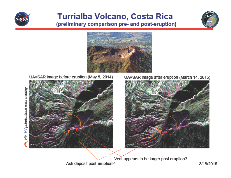
Back at JPL, we processed the data acquired over Costa Rica’s Turrialba volcano that has erupted last week. Polarimetric images before and after the first eruption showed there was no large scale deformation or changes, but there were clear changes and modifications to the summit during the eruption. InSAR data from before and after the eruption showed very small deformation signatures as well. The data are now being analyzed by UAVSAR investigators as well as USGS geologists.