CARVE continued flight operation in Alaska last week. CARVE flew over Fort Yukon, Nikolai and Innoko (see track plot below) for a total of 14 flight hours.
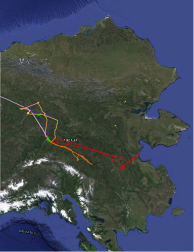
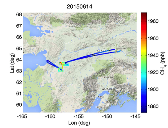
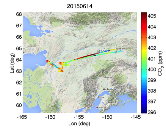
The Innoko flight on Sunday, June 14 shows enhanced CH4 and CO2 in the Innoko science area.

CARVE continued flight operation in Alaska last week. CARVE flew over Fort Yukon, Nikolai and Innoko (see track plot below) for a total of 14 flight hours.
The Innoko flight on Sunday, June 14 shows enhanced CH4 and CO2 in the Innoko science area.
Last week, we completed the second phase of the Europe campaign where we flew two sorties out of Munich, Germany over Oberpfaffenhofen Forest to test and refine repeat-pass PolInSAR and TomoSAR techniques for deriving forest height estimates and forest structure respectively (PI: Scott Hensley). The results from this study will be compared against those generated with the DLR F-SAR’s L-band radar.
We have since transited to Stavanger, Norway to participate in a Norwegian-led multinational controlled oil spill exercise (PI: Cathleen Jones and Ben Holt). We will be employing the L-band polarimetric SAR imagery acquired over a controlled oil spill on the North Sea to develop and validate a SAR-based capability to accurately measure oil volumetric fraction for future spill response. This experiment is part of the annual NOFO (the Norwegian Clean Seas Association for Operating Companies) Oil-On-Water exercise in the North Sea. This year international participants include Norway, Finland, France, and USA. Besides UAVSAR, the French Falcon 20 aircraft will operate its airborne SAR (SETHI) in polarimetric X-band and L-band modes and a hyperspectral imager. Researchers from Finland will also operate an airborne SAR onboard its Dornier 280-212 aircraft. Satellite imagery from Radarsat was also acquired on Wednesday, June 10.
During the second day of the exercise (June 10), we will image the controlled release of oil of 4 different densities and monitor the oil slicks as they dissipate over time. The onboard processor (OBP) will enable us to monitor in real-time the progression of the 4 oil slicks so we can adjust the flight lines to capture the oil slicks at the center of the image swath for maximum radar sensitivity.
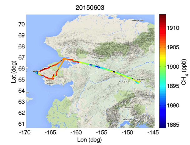
On June 2 – 4, CARVE flew to Innoko, Seward Peninsula and Bethel. The flight over the Seward Peninsula on June 3 showed enhanced CH4.
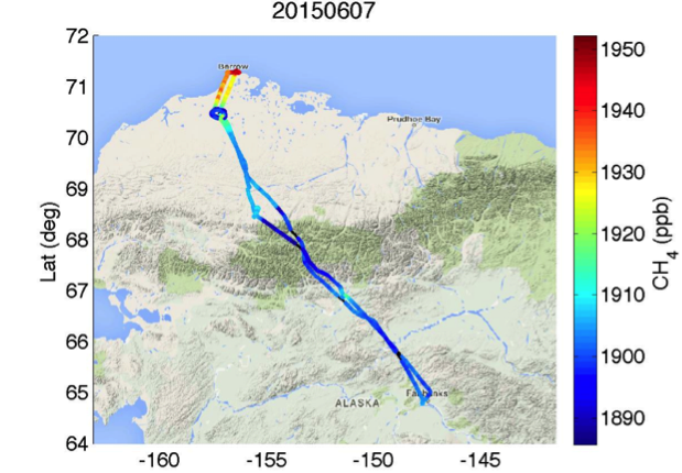
CARVE also flew on June 7 to Barrow.
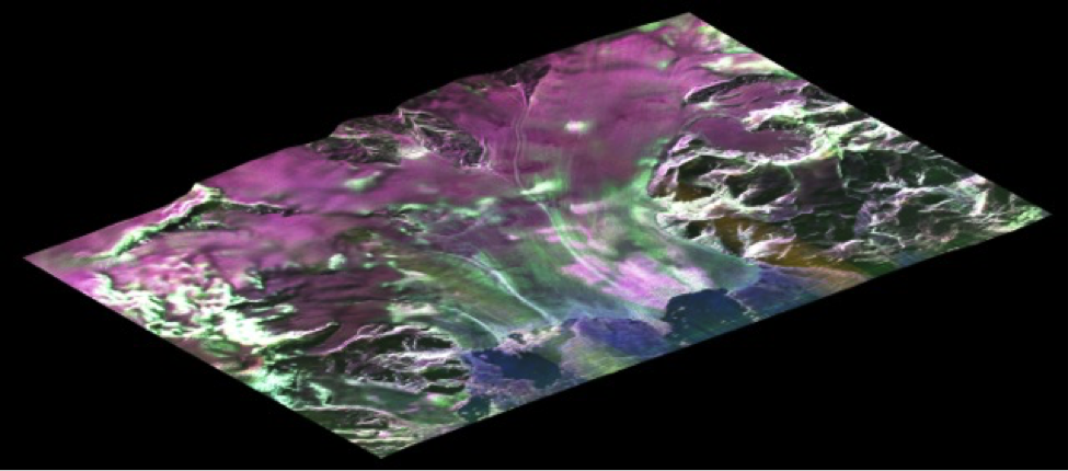
We have successfully completed the Iceland deployment to study the mechanics of glacier flow and their response to changing climate (PI: Mark Simons and Brent Minchew of Caltech) and volcanic deformation processes over Bardarbunga and Askja volcanoes (PI: Paul Lundgren of JPL). The glacier study is a follow-on observation of previous UAVSAR deployments in summer 2012 and winter 2014. Six of the eight flights were repeat observations of the same glaciers, which will provide a great data set for studying glacier dynamics from 1 day to 7 days apart. The observation of Bardarbunga volcano, which had the largest eruption in Iceland in the last century, will provide a baseline set of UAVSAR observations in the event of future dike intrusion events. Below is a polarimetric color-overlay image of Vatnajokull Glacier on the southern shore of Iceland generated by the quick look processor.
We have successfully completed three observations over Tonzi Ranch near Sacramento, California. This was the last of the 6 observations over Tonzi since 2013. The JSC G-III is now being reconfigured for Astronaut Return Mission. We will resume AirMOSS flights at the end of June. So far we have flown 40 flights in FY15, with about 30 flights to go before we wrap up our third and last year of observations.
Studies of Emissions and Atmospheric Composition, Clouds, and Climate Coupling by Regional Surveys (SEAC4RS)
Bob Herman presented a new analysis of convective injection of water into the stratosphere at the 2015 SEAC4RS Science Team Meeting (April 28 to May 1) at Caltech.
The JPL Laser Hygrometer Mark2 (JLH Mark2) measured large enhancements in stratospheric water from the NASA ER-2 aircraft during the SEAC4RS campaign. On five of the SEAC4RS flights, JLH measured enhanced stratospheric water greater than 7 ppmv over the summertime continental United States (CONUS). The JLH Mark2 instrument team consists of R. Herman (PI), R. Troy, R. Stachnik, and K. Chin. T. P. Bui (NASA ARC) provided correlated pressure and temperature measurements. See Figure 1 below for a sample water vapor profile.
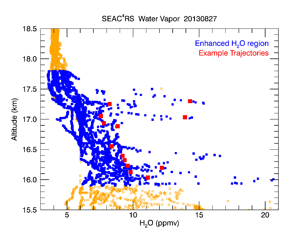
Figure 1. Water vapor profile from JLH Mark2, August 27, 2013.
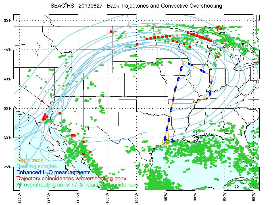
Trajectory modeling (E. Ray and K. Rosenlof, NOAA ESRL) connected the observed air parcels to overshooting convection from one to seven days earlier. Seven-day back trajectories were run with the FLEXPART model and NCEP CFS meteorology. Overshooting top detection products were obtained from GOES-East infrared satellite imagery (K. Bedka, NASA LaRC). Ice lofted by convection subsequently sublimated into water vapor in the stratosphere. See Figure 2 for example back trajectories and overshooting tops.
The L-band radar aboard the AFRC G-III departed for the 25-day Iceland/Germany/Norway deployment on Tuesday, May 19. We will spend 12 days in Iceland where 6 glacier and 2 volcano flights will be flown (PIs: Mark Simons and Paul Lundgren respectively). We will then transit to Munich, Germany and conduct two observations over two German forest sites in collaboration with DLR (PI: Scott Hensley). We will arrive in Stavanger, Norway on June 7 to participate in the week-long international North Sea Oil Spill exercise where scientists will use L-band polarimetric SAR imagery acquired over a controlled oil spill in the North Sea to develop and validate a SAR-based capability to accurately measure oil volumetric fraction for future oil spill response (PIs: Cathleen Jones and Ben Holt).
The P-band radar has been re-installed on the JSC G-III for campaigns in the East Coast and California during the second half of May. The radar’s Differential GPS (DGPS) experienced difficulty tracking satellite broadcast of real-time GPS correctors (NAVCOM service) reliably and we have had to replace the problematic unit (FM4) with a brand new spare (FM5) which works well on the ground but has not been flight-tested. We flew a calibration flight over Rosamond corner reflector array on Monday with FM5 and continued to have trouble with reliable DGPS solution. There are a couple of hypotheses that we need to investigate with FM5 (and FM4), but in the interest of time, we have re-installed an older unit (FM3) that worked well on both AirMOSS and UAVSAR flights before, but its satellite mask is about to expire on June 1. With FM3, we will be able to complete the May campaigns.
NASA has funded a new campaign for PRISM to map plankton concentration in the Southern Ocean (Michelle Gierach, JPL PI), as part of the larger NSF-funded ORCAS science campaign (Britton Stephens, U. Colorado PI). Flights are expected in January 2016.
With continued good weather, flew an additional 11.7 flight hours in 3 days.
CARVE flew science flights over Fort Yukon, Nikolai and Ruby.

May 11, Nikolai flight, CO2 and CH4 enhancements observed.


CH4 vs Longitude plot

At the conclusion of flight on May 13, the pilots reported a defective radio. For the next few days, the C-23 radios were serviced, but could not resolve the problem. On May 16, CARVE concluded the successful May campaign. CARVE flew a total of 40 science flight hours in 8 flight days in May. CARVE's grand total for Alaska science flight hours, since spring of 2012, is now over 800 science flight hours, which is 300 flight hours over goal!