You are here

News

05/21/2015

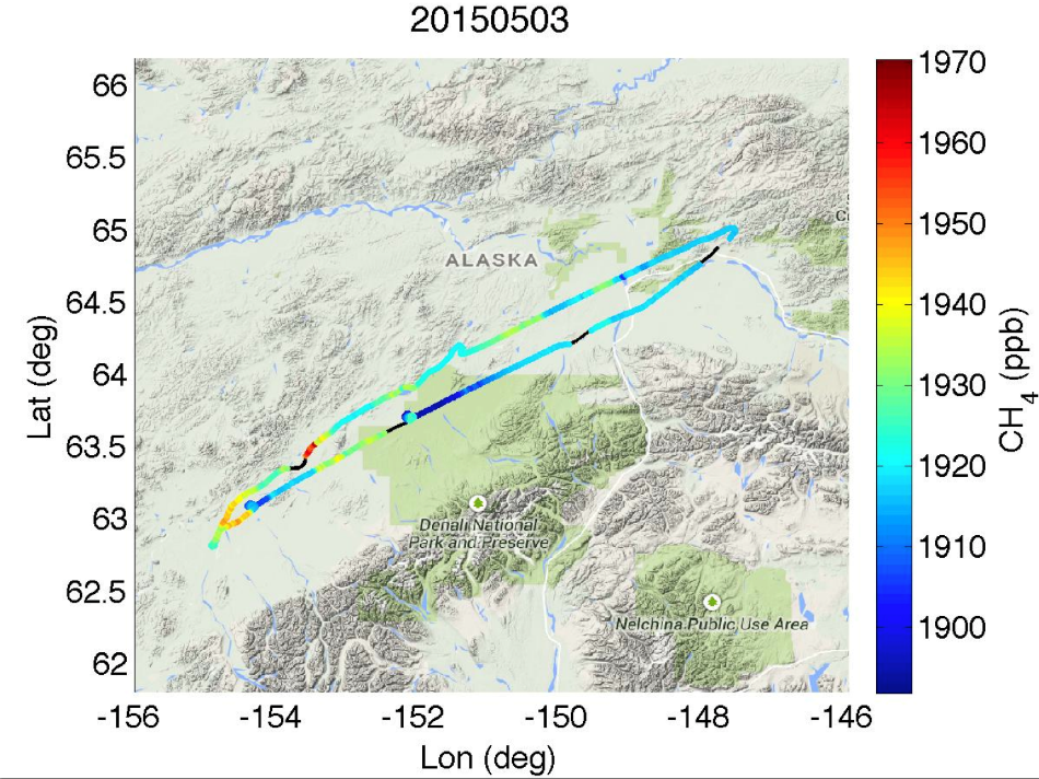
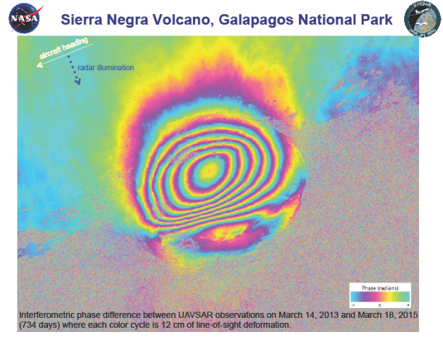
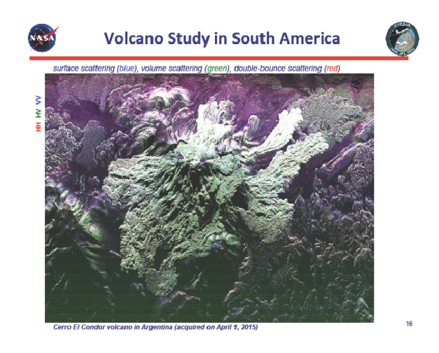
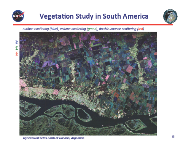
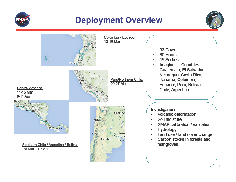
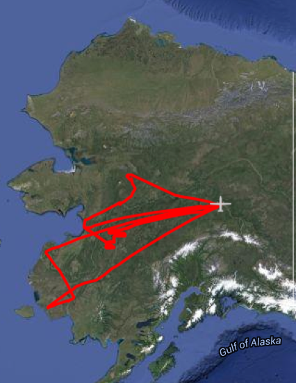
We are embarking on the month-long Central/South America deployment on Wednesday, 3/11/15.  We will have 21 flights (19 science sorties and 2 transit flights) over 33 days imaging 11 countries where 90% of the flight hours are associated with volcano studies and the remaining hours include wetlands, ecology, archaeology, and cross-calibration with the Argentinian airborne synthetic aperture radar system.  Attached is an overview of the deployment schedule and locations.  We received flight clearance for Ecuador, thanks to the diligent work by NASA HQ and all parties involved in the deployment planning.  Some of the volcanoes we are studying are quite active; they include Tungurahua (Ecuador), Villarica and Laguna del Maule (Chile/Argentina), Fuego (Guatemala), and Ubinas (Peru).  Dr. Paul Lundgren and his collaborators both in the United States and the host countries are quite excited about the data we will be collecting over these volcanoes, which will contribute to their modeling efforts towards the understanding of volcano activities.

05/14/2015

The L-band radar aboard the AFRC G-III has successfully completed the week-long deployment to the Louisiana Gulf Coast for a combined AirSWOT, UAVSAR, and AVIRIS-NG experiment in Wax Lake Delta.  In all, UAVSAR had 3 science acquisitions at low tide, rising tide, and high tide conditions, respectively.  Weather cooperated, and we managed to avoid rain during our stay in New Orleans.  Attached is a summary of the Wax Lake Delta experiment.  This week we have four local flights for San Andreas Fault monitoring and Sacramento Delta levee study, respectively.  Next week, we will depart for a 3-week Iceland/Germany/Norway deployment, where we will study temperate glaciers and volcanoes in Iceland, joint experiment and cross-calibration with the DLR F-SAR airborne radar, and the oil spill experiment in the North Sea west of Norway.

CARVE - Carbon in Arctic Reservoirs Vulnerability Experiment – Earth Ventures-1


With continued good weather, CARVE flew an additional 21 flight hours in 3 days. 

CARVE flew two science flights over the Innoko, and one science flight over Bethel. 

\

On May 4, enhanced CH4 was measured on the most Southern line, in the Innoko.


05/07/2015

The L-band radar aboard the AFRC G-III has embarked on a week-long deployment to the Louisiana Gulf Coast for coastal subsidence monitoring and a joint campaign with the AirSWOT radar at the Wax Lake Delta.  Scientists from JPL together with hydrologists from UT Austin and Rice University as well as ecologists from Louisiana State University have planned the Wax Lake Delta experiment to study sediment transport and delta formation.  They will use UAVSAR polarimetry for shallow water bathymetry and AirSWOT cross-track and along-track interferometry modes to study water level changes and surface velocity field respectively.  The UAVSAR and AirSWOT flights are coordinated with tidal conditions where they will acquire data at low tide, rising tide, and high tide.  There is an extensive ground campaign during the experiment where scientists will be taking measurements on the lake as well as in the wetlands.

05/07/2015

Last week, the CARVE science crew got ready for the up-coming CARVE May campaign.  The 

JPL crew arrived at Fairbanks on May 1.  With good weather, Carve flew on May 2-3 with flights over Fort Yukon and Nikolai, located in the Koyukuk valley Longitude vs Altitude vs Ch4 plot below, shows the boundary layer between 3,000 and 4,000 meters. 


Fort Yukon CO2 plot


Enhanced Ch4, on the way to Nikolai on 3 May, 2015


04/23/2015

We are taking a breather from flight operations while we process the data acquired during the month-long Central and South America deployment that was completed on April 12.  So far we have already released 141 polarimetric data sets of the 146 science data takes acquired.  We have also begun to generate the post-processed differential GPS solutions in preparation for repeat-pass interferometry processing.  Next week we will resume science flights based out of Palmdale prior to the week-long Louisiana Gulf Coast deployment in early May.

04/23/2015

This week the JSC G-III-mounted AirMOSS radar is stationed at Ellington Field, TX while we conduct observations in Mexico and Oklahoma.  The Mexico flights are our third and last annual observation over Chamela’s subtropical dry forest.  The flights over Marena, OK, a SMAP calibration site over temperate grassland, is the first observation of the year.  Both the radar and the aircraft have been performing well and at the end of the week, we will wrap up the spring observations while the aircraft will be reconfigured for astronaut return mission.

04/23/2015

Due to continued inclement weather this week in Alaska, CARVE was only able to fly two additional days.  14 April to North Slope, and 15 April to Upper Kuskokwim Valley.


Flight track below: 


North slope CH4 track plot: 

Upper Kuskokwim Valley Summary C02 track plot:

In the four flight days, we flew a total of 28 science flight hours.  With more storms approaching Alaska, and after CARVE had sampled all key areas, we concluded the CARVE April campaign. 


04/16/2015

Last week we completed three observations over Metolius, OR and we also conducted a long flight in Alaska over the permafrost for Dr. Mahta Moghaddam’s Interdisciplinary Science task.  All data were acquired without issues.  The JSC G-III has now returned to Texas where we will conduct flights in Mexico and Oklahoma for the next 10 days.  Attached is a quick look polarimetric image of permafrost just east of Norton Bay, Alaska.

04/16/2015

Due to continued inclement weather this week in Alaska, CARVE was only able to fly 2 days.  First flight was to Fort Yukon (4/9) and the second flight was over the Innoko (4/10).

Fort Yukon data summary:

Surface brightness temperatures -10 to +5 C
+1 to +5 ppm CO2 enhancements
+5 to +50 ppb CH4 enhancements 

Innoko data Summary:

Surface brightness temperatures -10 to +10 C
+1 to +11 ppm CO2 enhancements; background ~ 407 ppm
+20 to +250 ppb CH4 enhancements; background ~ 1920 ppb 


04/16/2015

We successfully completed the month long Central/South America deployment on Sunday, April 12.  In all, we flew 92 hours over 20 flights and acquired over 160 planned science data takes.  After we escaped the aftermath of the 50-year flood in Chile’s Atacama Desert region, we had much better luck in Santiago, Chile and Buenos Aires, Argentina.  We acquired data over the Andean volcanoes along the Chilean/Argentinian border, wetlands, agricultural areas, and calibration site selected by our colleagues at the Argentinian Space Agency, CONAE.  We held a very successful open house in Buenos Aires on Monday, April 6 that was hosted by the secretary general of CONAE.  We gave presentations and aircraft tour to high school students in the morning (including a GLOBE school) and to CONAE engineers/scientists as well as university researchers in the afternoon.  Attached are quick-look polarimetric images from Argentina’s agricultural fields near Rosario and Cerro El Condor volcano.  


Back home we have already generated polarimetric and browse InSAR products of data acquired during the first 10 days of the deployment.  One of the most striking images is an interferogram of Sierra Negra in the Galapagos where meter level deformation was observed over a two-year period (see attached image).  This volcano has been very active lately and scientists at JPL and University of Miami are studying the UAVSAR data together with their colleagues in Ecuador.

Pages