Air Surface Water and Ocean Topography
AirSWOT is planned to be the calibration/validation and science support instrument for the NASA/CNES/CSA SWOT mission. The initial development of AirSWOT was funded by NASA's SBIR (Small Business Innovation Research) program. This initial phase consisted in building key instrument subsystems and was implemented by Remote Sensing Solutions (RSS), with Delwyn Moller (serving as the PI (principal investigator)). The subsequent integration of the AirSWOT payload and its engineering checkout is currently being co-funded by NASA's Earth Science and Technology Office (ESTO) and NASA's SBIR program. The co-PI's for this phase are Ernesto Rodriguez (JPL) and Delwyn Moller (RSS). After completion of engineering checkout, in October, 2012, AirSWOT will be managed by the SWOT project (Ernesto Rodriguez, point of contact).
Instrument Suite
AirSWOT is an airborne instrument suite consisting of the following components:
KaSPAR (Ka-band SWOT Phenomenology Airborne Radar): The core of AirSWOT is a multi-purpose Ka-band radar, KaSPAR. This instrument will collect two swaths of across-track interferometry data (nominally, between nadir and 1 km and between 1km and 5 km, respectively) which can be used to obtain centimeter-level topographic maps of water surfaces and flood plains. In addition, KaSPAR implements an along-track interferometer that can be used to measure the temporal decorrelation of water surfaces, as well as the water radial velocity. Finally, the radar measurements can also be used as a nadir-looking synthetic aperture radar altimeter. Additional details, including expected performance, for KaSPAR are found in the KaSPAR White Paper.
 Cross-platform compatible integrated radar assembly |  Interferometer geometry showing overlapping swaths. |
In addition to the KaSPAR measurements, AirSWOT will provide complimentary measurements using facility instruments from NASA's Airborne Science Program, including:
Digital Camera System: For validation of surface water extent and for characterization of terrain type, simultaneous measurements will be collected using NASA Digital Camera System.
Precision IMU: Precision attitude and positioning information will be collected using NASA's Airborne Science Program facility Inertial Motion Units consisting of an Applanix POS LV system (NASA currently owns models 510 and 610).
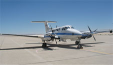
AirSWOT will nominally be hosted in a King Air B200 platform, such as NASA Dryden's platform.
