
The Delta-X fall campaign is well underway. The fall campaign is meant to capture the hydrodynamics and vegetation patterns of the region while the Mississippi River discharge is near its lowest point and when vegetation has reached its peak biomass. Delta-X already captured the highest annual river discharge when herbaceous vegetation is just starting to grow in the Spring.
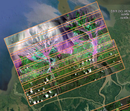
AVIRIS-NG flew 4 flights over the last week, starting on August 18th, and completed Atchafalaya vegetation and water quality lines. It also flew Terrebonne vegetation and water quality lines, nearly completing the Terrebonne West vegetation lines. Image below shows quick look image of AVIRIS-NG lines over Wax Lake Delta in the Atchafalaya basin.
AirSWOT also flew 4 flights: over Atchafalaya high & receding tide and Terrebonne East & West high tide to measure water surface elevation.
Together, AirSWOT and AVIRIS-NG flew 3 joint flights. UAVSAR is scheduled to join the campaign on Saturday August 28th flying on the ARFC G-III.
Field teams and have been taking measurements on the ground coincident with the airborne instruments as much as possible. Water Quality (Boston University) team collected water samples as well as reflectance to coincide with AVIRIS-NG overflight. The Islands Team (Caltech and University of Texas) collected depth profiles, sediment profiles, as well as water samples and ADCP transects (i.e. river discharge measurements) to complement data collected by the ADCP (JPL and University of North Carolina) and Water Quality teams.
The Vegetation Team (Florida International University) collected vegetation samples (pictured below), root and soil cores, and characterized subplot representativeness.