We successfully conducted two Mexico flights last week to monitor earthquake fault movements in Baja California. Local flights for this week have been delayed by a couple of days due to an aircraft maintenance issue. Iceland deployment is on schedule to depart on January 28, and we are preparing for a visit by the US ambassador to Iceland.
A paper written by UAVSAR PIs Cathleen Jones and Ron Blom on using repeat-pass UAVSAR data to study a giant sinkhole in the Mississippi River delta was published in Geology. The paper was published in Geology, highlighted in Nature, and reported online by “livescience:”
http://geology.gsapubs.org/content/early/2013/12/12/G34972.1
http://www.nature.com/nature/journal/v505/n7482/full/505135d.html
http://www.livescience.com/42103-radar-catches-bayou-corne-sinkhole-form.html
Using data acquired in June 2011 and July 2012, they observed a surface movement as much as 26 cm towards where the 110-meter-wide sinkhole appeared in August 2012, demonstrating the potential of using repeat-pass InSAR to predict the formation of these potentially catastrophic sinkholes and their growth rate.
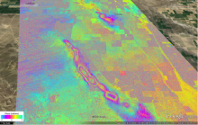
We continue to process repeat-pass browse products and categorize any data acquisition and processing issues as we go. We came across a repeat observation of Central California separated over 2 years (November 2, 2011 and November 25, 2013) with surprisingly good coherence where we observed ground subsidence as much as 25 cm over the Belridge Oil Field southwest of Lost Hills, California. The browse interferogram overlaid on Google Earth is attached here showing the ground subsidence over the Oil Field (each color cycle is 12 cm of deformation).

