
The UAVSAR-Ka topographic InSAR (a.k.a. GLISTIN-A) aboard the AFRC C-20 jet successfully completed the week-long Mauna Loa volcano rapid response deployment (PI: Paul Lundgren). We conducted 3 flights over the active lava flow as well as mapped the topography of both Mauna Loa and Kilauea volcanos. The SAR-Fusion Optical/SWIR cameras (PI: Andrea Donnellan) were also onboard to take coincident imagery for generating high resolution Digital Elevation Model (DEM) for comparison with the GLISTIN-A DEM.
On December 7 (Wednesday), we imaged the Mauna Loa volcano in its entirety and repeated the flight lines over the active lava flow at the end of the flight to see if we are able to detect lava thickness changes after two hours. UAVSAR Science Coordinator Naiara Pinto brought the raw radar and optical data back to Pasadena via commercial air on Wednesday night for rapid processing. We were able to deliver preliminary DEM by Friday morning to Paul Lundgren and his colleague Hannah Dietterich at Alaska Volcano Observatory of USGS, approximately 1 day after receipt of the raw data.
The USGS/HVO team was able to compare the GLISTIN-A DEM to their baseline DEM from 2005 to quickly determine the change in lava thickness and lava volume for eruption response (see Figure 1). Dr. Dietterich and her team are updating their lava flow forecasting models and tracking eruption rates in support of Civil Defense, HI emergency management agency to prepare for the potential of the lava flow reaching and burying the highway between Kona and Hilo. Fortunately, the eruption rates have slowed significantly by the second day of our deployment and the highway was no longer in threat.
The second figure is the lava flow thickness generated by Paul Lundgren by comparing GLISTIN-A DEM to TanDEM-X DEM (data acquired between 2010-2015), showing lava flow thickness in excess of 20 m at the lava fronts.
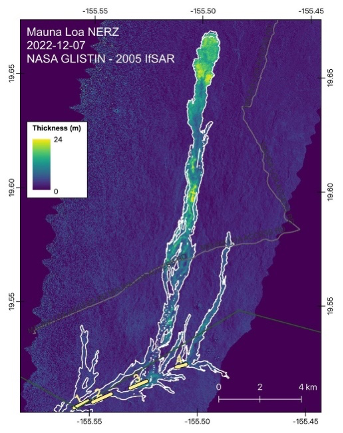
The USGS/HVO team was able to compare the GLISTIN-A DEM to their baseline DEM from 2005 to quickly
determine the change in lava thickness and lava volume for eruption response
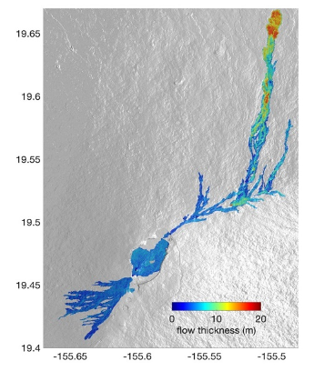
lava flow thickness generated by Paul Lundgren by comparing GLISTIN-A DEM to TanDEM-X DEM (data acquired
between 2010-2015), showing lava flow thickness in excess of 20 m at the lava fronts.