
The P-band Synthetic Aperture Radar aboard the JSC G-III has successfully completed 7 of 9 science flights in support of the summer 2017 ABoVE (Arctic-Boreal Vulnerability Experiment) Airborne Campaign in Canada and Alaska. Last Wednesday (9 August), we imaged the tundra and boreal forest near and around Great Slave Lake in Northwest Territories, Canada before transiting to Fairbanks on Thursday (10 August), where we imaged the boreal forest in Yukon Territory, Canada and long-term study sites in Delta Junction just southeast of Fairbanks. On Sunday (13 August), we imaged permafrost near Prudhoe Bay and Barrow in North Slope as well as Seward Peninsula. On Monday (14 August), our focus area was Southwest Alaska, where we imaged Yukon Delta National Wildlife Refuge, Katmai National Park and Preserve, and one transect across Lake Clark National Park and Preserve. On Tuesday (15 August), we conducted a TomoSAR experiment over Delta Junction, in which multiple passes over the target area were acquired with tightly controlled separation between the flight tracks, enabling three-dimensional tomographic imaging of forest structure.
Attached are two color composite quick look images where red, green, blue represent HH, HV, VV polarization channels respectively. The first quick look image is data acquired on 8 August over Peace-Athabasca Delta showing the complex biome in the delta region with Athabasca River to the south and Slave River to the north. The second quick look image is data acquired on 13 August over permafrost near the Beaufort.
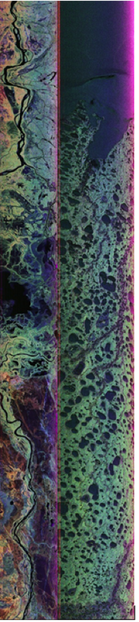
Sea shoreline in North Slope, covering three CALM (Circumpolar Active Layer Monitoring) locations west of Colville River where active layer depths and permafrost have been monitored for decades.