
The Ka-band Glacier and Ice Surface Topography Interferometer (GLISTIN-A) is currently on deployment in Honolulu, HI to study the Kilauea volcano eruption. The objective of this deployment is to use GLISTIN to detect changes in Kilauea’s topography associated with the new lava flows, with the goal of measuring the erupted volume as a function of time and ultimately the total volume of the event. If successful, Principal Investigator Paul Lundgren and his colleagues at USGS plan to use the GLISTIN data to quantitatively evaluate their models for evolution of volcanic processes. Here’s a NASA press release that highlight’s the research effort:
https://www.nasa.gov/feature/help-from-above-nasa-aids-kilauea-disaster-response-1
So far we have imaged the southeastern portion of the Big Island covering Kilauea summit and the east rift zone down to the coast on three different days: May 18, 19, and 21. The data from May 18 & 19 were hand-delivered by Paul Lundgren to JPL on Sunday night where members of the processing team were waiting to start processing the data to determine if the radar has sufficient sensitivity to measure the topography changes associated with new lava flows. Within 24 hours we were able to generate some preliminary amplitude and height products that showed changes due to lava activities from May 18 to May 19.
The current plan is for GLISTIN to remain in Honolulu to make two more observations within the next week as volcano eruption continues to be active.
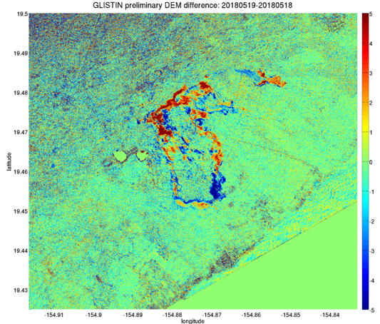
Figure of preliminary GLISTIN height differences (courtesy Paul Lundgren) showing new lava activities in Leilani Estates within the one day period. The color represents height changes in meters. Areas with intense orange and red experienced lava growth of a few meters whereas areas with bluish hue experienced “height loss,” likely due to lava flows toppling trees in the path. This is really good news as we have demonstrated that the GLISTIN radar has sufficient sensitivity to measure topography changes associated with new lava flows! Much work remains to be done to determine if scientists can extract the lava thickness from the DEM (digital elevation model) changes after accounting for tree height changes and measurement noise.