You are here

AVIRIS-NG

AVIRIS-NG - (Airborne Visible and Infrared Imaging Spectrometer-Next Generation)

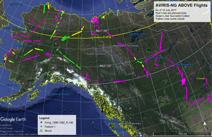
The Next Generation Airborne Visible and Infrared Imaging Spectrometer (AVIRIS-NG) departed Canada on the King Air B200 on 26 August.   The flight crew completed NASA funded Methane collections in Alberta.   The aircraft transited through the Pacific Northwest and remained overnight (RON) on 26-27 August in Portland, OR and collected Methane targets in the region.  

AVIRIS-NG (Airborne Visible and Infrared Imaging Spectrometer-Next Generation)

The Next Generation Airborne Visible and Infrared Imaging Spectrometer (AVIRIS-NG) is currently supportin the NASA Arctic Boreal Vulnerability Experiment (ABoVE). This has been a successful week of flying for the AVIRIS-NG team. 

Current Google Earth Image of all flight lines (red), lines

collected successfully (green), and lines with clouds (yellow).

AVIRIS-NG (Airborne Visible and Infrared Imaging Spectrometer-Next Generation)

AVIRIS-NG has been flying from the Burbank Airport for the NASA Funded Methane Survey flights on the commercial King Air from Dynamic Aviation.  From Thursday June 14 to Tuesday June 20 a large amount of AVIRIS-NG data has been collected across the State of CA over Diaries, Gas Infrastructure, and Petroleum Refineries.

AVIRIS-C has been flying on the NASA ER-2.   The flights on the ER-2 are for the fifth year of HyspIRI CA flights.  Data was collected over Tahoe June 20 and Santa Barbara June 19.    

AVIRIS-NG (Airborne Visible and Infrared Imaging Spectrometer-Next Generation)

The Classic Airborne Visible and Infrared Imaging Spectrometer (AVIRIS-C) has been flying the HyspIRI CA collections on the NASA ER-2 from Armstrong Palmdale Hangar 703.   In the last week collections have occurred over the Santa Barbara Box (June 8), Southern CA Box (June 12), Yosemite Box (June 6) and Bay Area Box (June 13).  The Santa Barbara Box will need to be recollected due to cloud cover.   The Associate Administrator, Dr. Thomas Zurbuchen, visited the HyspIRI deployment on Friday, June 8.

AVIRIS-NG (Airborne Visible and Infrared Imaging Spectrometer-Next Generation)

The next generation Airborne Visible and Infrared Imaging Spectrometer (AVIRIS-NG) successfully completed 2 calibration flights under the NOAA Geostationary Operational Environmental Satellite-R Series (GOES-R) Advanced Baseline Imager (ABI).  Flights were conducted on the NASA ER-2 from the Armstrong Palmdale Hangar 703 on March 23 and March 28 over Ivanapah Playa and the Sonoran Desert in Mexico.

AVIRIS-NG (Airborne Visible and Infrared Imaging Spectrometer-Next Generation)

The next generation Airborne Visible and Infrared Imaging Spectrometer (AVIRIS-ng) is currently supporting the NOAA GOES-R Advanced Baseline Imager Calibration and Validation Campaign. The first flight was conducted on March 21 over the West Coast to image clouds associated with the low pressure system moving across California. 

AVIRIS-NG (Airborne Visible and Infrared Imaging Spectrometer-Next Generation)

The Classic Airborne Visible and Infrared Imaging Spectrometer (AVIRIS-C) is in the final week of the HyspIRI Airborne Preparatory Campaign at Marine Corps Base Hawaii on the Island of Oahu.  The campaign has collected a majority of the coral reef sites, and repeated coverage of the Kilauea and Mauna Loa active volcanoes. 

The next generation Airborne Visible and Infrared Imaging Spectrometer (AVIRIS-NG) had a second successful flight on the NASA ER-2 (809).  Data was collected over Moffett Field and Jasper Ridge which are both long term validation sites for AVIRIS.  

Pages

Subscribe to RSS - AVIRIS-NG