ASO - Airborne Snow Observatory
ASO is still in the field collecting survey data. This past week, the team was able to complete surveys over Cherry and Eleanor in Northern California as well as the Rosamond Dry Lakebed.

ASO is still in the field collecting survey data. This past week, the team was able to complete surveys over Cherry and Eleanor in Northern California as well as the Rosamond Dry Lakebed.
The ASO team is back to surveying in Northern CA. This weekend the flight team took advantage of the lull of Columbus Day Weekend and completed a large survey in a difficult to access airspace over Kings Canyon National Park.
The Airborne Snow Observatory finished up all of our summer Colorado surveys. We’ve flown a total 83.5 flight hours since September 10 and have surveyed the Rio Grande and Conejos basins as well as Ouray and San Miguel counties and large portions of Montrose and San Juan counties. The plane transited to Mammoth Lakes, CA and did a test to determine data quality due to smoke produced by nearby fires and determined the smoke at these levels to be a non-issue. Later this week when the clouds clear up we will start surveying our CA snow-free targets.
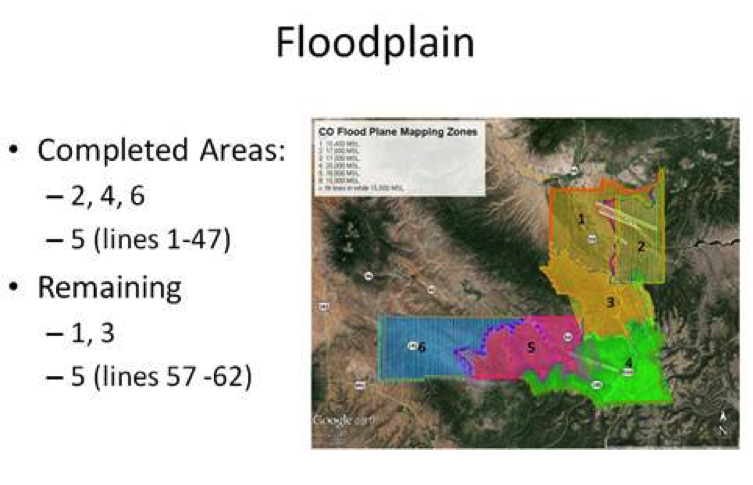
Since the ASO team deployed for summer surveys on September 10 we have covered a lot of survey area. We’ve flown about 56 flight hours, collected data over Devil’s Golf course in CA, Rio Grande and Conejos basins in CO for snow baseline data, and about half of our CO Floodplain mapping areas which include Sam Miguel, Ouray, parts of Montrose and San Juan counties in CO (also includes the Gold King Mine spill area).
The Airborne Snow Observatory has flown over the Tuolumne River Basin and other local watershed areas (e.g., Merced) 44 times on 12 separate days in the past month. Data was collected using a Riegl LMS Q1560 scanning laser altimeter. Data was collected using a Riegl LMS Q1560 scanning laser altimeter and a ITRES CASI-1500 imaging spectrometer. Using advanced algorithms developed at JPL, the snow water equivalent (SWE) in the area has been determined and plotted against last year’s SWE in the same area.