You are here

News

06/30/2016

The Hawaii operational readiness test (ORT) campaign was completed last week.  The campaign met or exceeded all success criteria, while under running the projected budget. 

 See https://coral.jpl.nasa.gov/alt_locator/ for all quick-look data. All data is at JPL and ORT runs will be added to the Data Portal as they are processed.

The LA Times reported on the condition of the Great Barrier Reef following the International Coral Reef Symposium in Honolulu: http://www.latimes.com/nation/ct-coral-reefs-plea-australia-20160625-story.html

06/30/2016

AirGravity Science element:  With reasonable weather last week, OMG’s AirGravity contractor (Sander or SGL) flew four science days last week.  SGL flew for a total of 56 flight hours using two SGL research aircraft.

06/24/2016

The Classic Airborne Visible and InfraRed Imaging Spectrometer (AVIRIS-C) has been flying the California HyspIRI Preparatory Airborne Campaign on the NASA ER-2 from Armstrong Flight Research Center.  On June 16, there was a HyspIRI Prep flight with AVIRIS-C over the large Southern California Box.  On June 17, there was another flight over the Santa Barbara Box that imaged the Sherpa Wildfire, and was coordinated with the DC-8 flying to KORUS-AQ atmospheric payload for the Student Airborne Research Program (SARP). 

06/24/2016

Three runs of the two Kaneohe Bay, Oahu flight lines were completed.  Although the cloud cover was pretty bad for most of the line, the area where we had coincident in-situ measurements (optical concurrent, benthic and productivity within the past week), the clouds were largely absent.

Quick looks for all lines over Kaneohe Bay are now linked to the online flight logs at: http://prism.jpl.nasa.gov/cgi/flights.cgi?step=view_flightlog&flight_id=prm20160620t.

06/24/2016

AirGravity Science element:  With reasonable weather last week, OMG’s AirGravity contractor (Sander or SGL), flew four science days last week.  

Kangerlussuaq

06/14/2016

ASO delivered last week’s data products to the CA water managers who updated their late-season predicts using the ASO data. These data were extremely valuable as we are into the portion of the season where many of the snow sensors have melted out. This week’s Tuolumne survey just completed on June 14. 

06/14/2016

The Classic Airborne Visible and Infrared Imaging Spectrometer (AVIRIS-C) is flying on the NASA ER-2 from Armstrong Flight Research Center for the CA HyspIRI Airborne Campaign.  June 9 was a successful flight over the Tahoe HyspIRI Box, which included the King Fire Scar area.   Flights are scheduled through the end of the month.

An AVIRIS-C Image over Lake Tahoe.   The pilot left the sensor on during the turn, which created this interesting image.

06/14/2016

AirGravity Science element:  With reasonable weather last week, OMG’s AirGravity contractor (Sander or SGL) flew 4 science days last week.  

SGL flew for a total of 65 flight hours using two research aircraft.

06/03/2016

A NASA press release highlighting Dr. Cathleen Jones, her Louisiana State University and UCLA colleagues’ research on land subsidence in New Orleans and surrounding areas was published on May 16.  This study based on data acquired by UAVSAR between June 2009 and July 2012 observed the highly variable rates of sinking due to a combination of natural geologic and human-induced processes.  The highest rates of sinking were observed along the Mississippi River around major industrial areas in Norco and Michoud.  The study found that groundwater pumping and dewatering (surface water pumping to lower the water table to prevent standing water and soggy ground) were the primary contributors to regional subsidence.  The study results as well as more recent UAVSAR data will be used to improve models of subsidence for the Mississippi River Delta that decision makers use to inform planning, flood modeling, and response strategies, thus improving public safety.  The subsidence rates were illustrated in the graphics below.

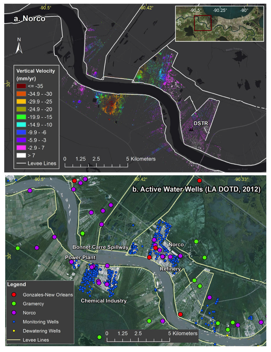
Top: Subsidence rates around Norco, Louisiana, and the location of flood protection levees (white). Bottom: Location of water wells active in 2012, local industry and the Bonnet Carre Spillway. The highest subsidence forms a bowl within the major industry site to the south of the river.

Credits: NASA/JPL-Caltech, Esri

Pages