You are here

News

04/02/2015

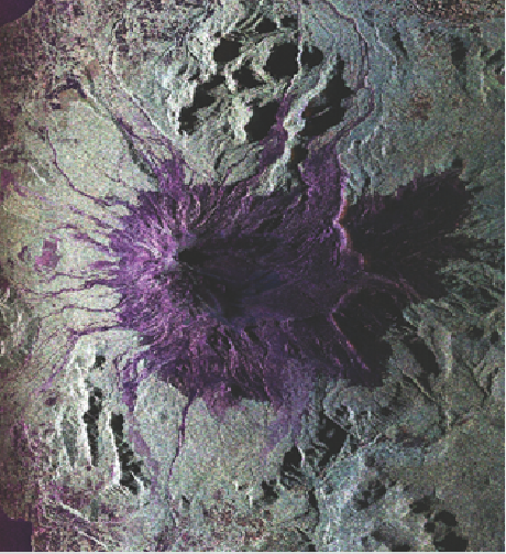
We have had some unexpected excitement in Antofagasta, Chile last week.  Heavy rains in Chile’s Atacama Desert region last Tuesday/Wednesday caused flash floods, major power and communication outages, as well as airport closure.  We had to scrub two local flights out of Antofagasta due to air traffic disruption and headed to Santiago a day early to regroup.  In addition, we were not able to secure Bolivia flight clearance to image Bolivia without a Bolivian observer onboard the aircraft.  As a result, we were able to consolidate all the volcano observations near the Chile/Argentina border in two flights (Saturday and Monday).  Quicklook imagery and flight track analysis showed that we acquired all planned data takes within the prescribed 10 m tube and produced some stunning imagery over the volcanoes and glaciers.  Here’s a color composite of the polarimetric image of the Villarrica volcano we acquired on March 30.  This volcano has erupted in early March and continues to be very active.  We had an open house in Santiago yesterday (Tuesday) that was well attended by researchers and college students.

04/02/2015

On 24 and 25 March, CARVE flew two test flights both in the San Joaquin Valley (SJV). Both test flights were successful and CARVE is ready to depart for Fairbanks, Alaska. Data below shows enhanced CO2 and CH4 while flying low level (500 feet above ground level) over the southern SJV area.


03/26/2015

During the second week of our Central/South America deployment, we conducted 4 science flights where we imaged volcanoes in the Galapagos and the Andes in Ecuador, Peru, and Northern Chile.  We also imaged coastal wetlands in Ecuador as well as Nazca lines, a UNESCO World Heritage Site consisting of a series of ancient geoglyphs located in the Nazca Desert in southern Peru.  The volcanoes and the Nazca lines were all previously imaged in the 2014 campaign and scientists will be looking for changes due to volcano inflation/deflation and disturbances in the case of the Nazca lines using repeat-pass InSAR techniques.  NASA502 is now based in Antofagasta, Chile for the next few days to observe volcanoes in Northern border between Chile and Argentina.

On this deployment, we have conducted outreach events in Panama City and Ecuador, where UAVSAR investigators gave overview science talks and the aircraft crew gave tours of the aircraft.  The outreach event in Lima, Peru was cancelled at the last minute due to issues with granting access to visitors at Jorge Chavez International Airport.  The local press in Panama and Ecuador released several articles on UAVSAR’s visit, including this from Panama:

http://www.prensa.com/salud_y_ciencia/Nasa-estudia-Cuenca-Canal_0_4162083941.html

And these two articles from Ecuador:

http://www.andes.info.ec/es/noticias/mision-nasa-visitara-ecuador-realizar-estudios-volcanes-manglares.html

http://www.elcomercio.com/tendencias/nasa-capta-radiografia-volcanes-manglares.html

Back at JPL, we processed the data acquired over Costa Rica’s Turrialba volcano that has erupted last week.  Polarimetric images before and after the first eruption showed there was no large scale deformation or changes, but there were clear changes and modifications to the summit during the eruption.  InSAR data from before and after the eruption showed very small deformation signatures as well.  The data are now being analyzed by UAVSAR investigators as well as USGS geologists.


03/19/2015

The first week of our Central/South America deployment has been full of excitement both from the scientific and logistic standpoints.  We’ve successfully conducted 5 science flights, imaging volcanoes in Central America, Colombia, and Ecuador as well as the Panama Canal Watershed.  

While we were in Panama, we received news from NASA HQ on Friday morning that the Turrialba volcano in Costa Rica had just erupted and this unique opportunity gives NASA scientists the chance to observe volcanic deformation and other eruptive features over short time scales.  We were able to rearrange our schedule and observe the Turrialba volcano on Saturday, March 14.  The data acquired on March 14 as well as the prior observation on March 11 has been sent back to JPL for priority processing and we expect to have some preliminary results within 48 hours (by March 19).  

03/12/2015

The JPL Laser Hygrometer (JLH), PI Robert Herman, was flown on board the Northrop-Grumman Corporation (NGC) Beechcraft G-II aircraft on March 5, 2015, taking water vapor measurements in the upper troposphere over the NASA Armstrong Flight Research Center (AFRC) test range.  The aircraft took off at 11:00 am and landed around 2:30 pm, loosely coordinated with the landing of the AFRC Global Hawk (ATTREX/CAST), enabling the comparison of meteorological data between the two sensors.

Preliminary indications are that the JLH instrument performed well.  Near-real-time water vapor data was sent by Ethernet to the vehicle management computer onboard the aircraft.  A commercial humidity sensor was also flown, but it lacked the requisite sensitivity at high altitude, low humidity conditions.

03/05/2015

We completed one calibration flight and two science flights to Mexico for earthquake fault monitoring last week.  This week we have two flights on the calendar, one science flight to monitor Sacramento Delta levees and an engineering flight to test experimental modes (time permitting).  The Central/South America deployment is scheduled to begin on March 11 (Wednesday) pending the close out of the following outstanding issues: aircraft maintenance, flight track tube performance, open flight requests, and diplomatic clearances (received 6 of the 12 countries).  We continue to work the details of education outreach events with the US embassies in the host countries.  We plan to have open houses at Panama City, Guayaquil, Lima, Santiago, and Buenos Aires.

02/26/2015

JPL Airborne Imaging Spectroscopy 

The Classic Airborne Visible and Infrared Imaging Spectrometer (AVIRIS-C) has completed the CalWATER 2 flights on the NASA AFRC ER-2.  Results from the three phases of water Level 2 reflectance retrieval algorithm are indicating exciting results of mixed phase cloud identification off the coast of California.  The new Level 2 products are showing that AVIRIS-C has the ability to separate liquid and ice clouds.  In addition JPL and GSFC Earth Observing System  (EOS - Aqua and Terra)  are working on developing Moderate Resolution Imaging Spectroradiometer ( MODIS) cloud retrievals with AVIRIS-C data from CalWATER 2.  

02/26/2015

We have successfully completed the Costa Rica deployment where we observed the tropical forest biome in La Selva on February 18, 21, and 24 respectively.  Science team members were in the field on the last two flights making soil moisture measurements and collecting vegetation information and other ancillary data.  We also had the opportunity to acquire P-band radar data in experimental modes during the last two flights, the 60 MHz bandwidth mode (instead of the typical 20 MHz mode) and the split bandwidth mode where we alternately transmitted 80 MHz bandwidth chirps centered at 400 MHz and 320 MHz respectively.  These modes were only tested in the lab and have never been used by AirMOSS in the United States before due to the 420-440 MHz frequency license restriction we have in the US.  We were able to generate quick look imagery to verify that the experimental modes worked successfully (see attached images with low and high sideband data).  The split band mode will allow us to investigate differential foliage/ground penetration at slightly different frequencies.

02/19/2015

In preparation for the Central/South America deployment in mid-March, we are compiling a collection of scientific significance briefs based on UAVSAR data acquired in prior years. Here is one from Dr. Kyle McDonald of the City College of New York that utilized UAVSAR data to image active and dormant river and stream channels in the Amazon basin that helped shape the evolution of plant and animal species in this mega-diverse ecosystem.  This technic is directly applicable to space-based radar missions such as NISAR and Japan’s ALOS-II missions. 

02/19/2015

In preparation for the Central/South America deployment in mid-March, we are compiling a collection of scientific significance briefs based on UAVSAR data acquired in prior years.  Here is one from Dr. Kyle McDonald of the City College of New York that utilized UAVSAR data to image active and dormant river and stream channels in the Amazon basin that helped shape the evolution of plant and animal species in this mega-diverse ecosystem.  This technic is directly applicable to space-based radar missions such as NISAR and Japan’s ALOS-II missions. 

Pages