California State University, Los Angeles (CSULA), delivered hardware and supporting documentation that will allow integration of AVIRIS-ng or HyTES (as currently configured) into NASA's Earth Research 2 (ER-2) aircraft equipment bay (Q-bay). This is the culmination of a 1-year JPL-sponsored senior design project to develop the integration approach, accommodate the electronics, and fabricate and test the primary sensor support structure.
You are here
News
06/19/2014
With improved Alaska’s weather the week of 15 June, CARVE flew 5 science flights for a total of 30 science flight hours and covered greater than 5000 nautical miles. For the month of June, CARVE flew a total of 47 science flight hours in 14 calendar days.
06/19/2014
We successfully completed three local flights in the past week, imaging earthquake fault activities in the Salton Trough and Central California as well as subsidence in the Sacramento Delta region.
06/05/2014
UAVSAR completed three local flights in the past week, imaging Hayward Fault, northern and central sections of the San Andreas Fault, and San Joaquin Valley for the SMAP mission. Six additional flights are scheduled before the 5-week maintenance period of the aircraft will begin on June 23
06/05/2014
We have successfully completed 5 of the 6 P-band radar observations and managed to avoid several rain storms over our sites. The Purdue aircraft with the Picarro greenhouse gas analyzer planned to fly over Harvard Forest on June 1. The flux towers and ground sensors at our sites are all operating well.
06/05/2014
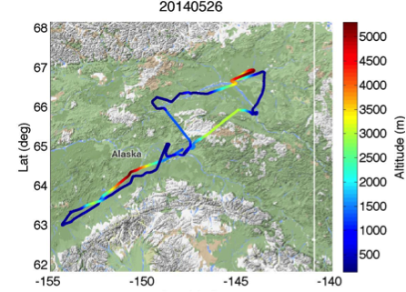
On May 26, CARVE flew two separate flights. The first flight was to Fort Yukon, and the second was to Minto flats and Nikolia.
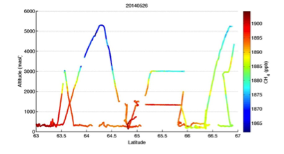
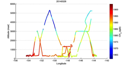
We observed low C02 and enhanced CH4.
Below is a new product: CH4 Altitude vs. Lat and Long . Breaks in data are due to instrument calibration periods.
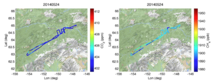
On May 29, we flew over Minto and to Nikolia, Data shows slight CO2 draw down, and elevated CH4 near Nikolia.
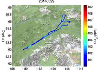
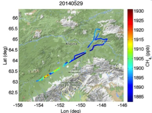
On the same flight, CARVE achieved its PLRA Major Milestone Goal of 500 Science flight hours in Alaska.
05/29/2014
The summer campaign season began May 27. The first deployment is based out of Harrisburg, PA where we will observe Duke Forest, NC and Harvard Forest/Howland Forest in New England during the next 10-14 days. Weather on the East Coast will be challenging during the next few days as thunderstorms are predicted. We should have sufficient calendar margin to work around the rainy days and make three observations over each site. After Harrisburg, we will move our base of operation to Bozeman, MT where we will observe Metolius, OR and BERMS, Saskatchewan on alternating days.
05/29/2014
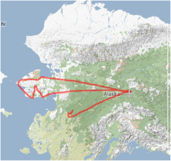
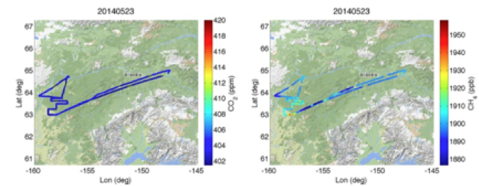
Between May 23 - 25, CARVE flew 3 science flights which included, Nome, Innoko, and Minto Flats. (Flight tracks below)
May 23 CARVE science flight data from the Nome area show enhanced CO2 and CH4.
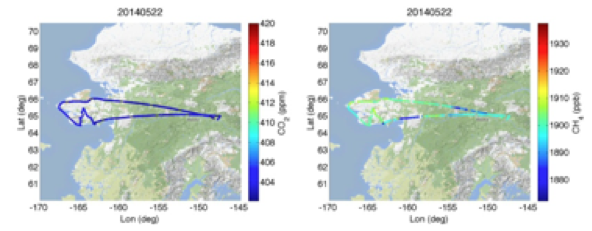
May 24 CARVE science flight data from Innoko shows CO2 were close to background, but CH4 exhibited 20 to 50 ppb enhancements.

May 25 CARVE science flight data CO2 concentrations were again close to background levels,
CH4 exhibited +10-20 ppb enhancements with localized enhancements up to +80 ppb.


May 23 CARVE science flight data from the Nome area show enhanced CO2 and CH4.

May 24 CARVE science flight data from Innoko shows CO2 were close to background, but CH4 exhibited 20 to 50 ppb enhancements.
May 25 CARVE science flight data CO2 concentrations were again close to background levels,
CH4 exhibited +10-20 ppb enhancements with localized enhancements up to +80 ppb.
05/22/2014
The L-band radar onboard the NASA 502 aircraft is conducting 2-3 local flights per week through June 20, when the aircraft will enter its 6-week maintenance period. We are acquiring data over the San Andreas Fault in Central California (PI: Zhen Liu) as well as Baja California, Mexico (PI: Eric Fielding). The processing team has begun producing browse Repeat Pass Interferometric (RPI) products for the Central/South America deployment and has released 73 pairs of data products, about half of the total number of flight lines acquired. This is an impressive turnaround considering most of the raw radar data were returned to JPL less than 2 weeks ago. PIs can now begin to submit refined RPI processing requests online.
While the UAVSAR team was in New Orleans, they were interviewed April 9 by CBS This Morning about a science flight over the Gulf Coast for a story entitled, "Inside NASA's high-tech strategy to predict sinkholes", as seen here
This news segment highlighted the research performed by UAVSAR PIs Cathleen Jones and Ron Blom on detecting surface deformation prior to the sinkhole formation with RPI data from UAVSAR .
05/09/2014
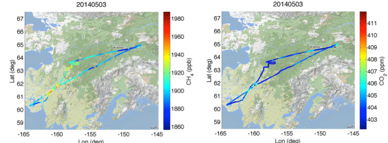
The CARVE aircraft departed California April 28, after three successful test flights in the San Joaquin Valley, and arrived in Fairbanks on April 30. With good weather on May 3, CARVE flew its first 2014 flight to Bethel. In route CARVE observed elevated CH4 and C02 signals Bethel and Innoko areas.