You are here

News

03/06/2014

AirSWOT has been reintegrated on the DFRC B200 and has completed two engineering flights.  The first engineering flight (February 20) consisted of four racetrack pattern over Rosamond radar corner reflectors followed by a cabin pressure check climb to Flight Level (FL) 350.  We discovered an issue with the configuration of the GPS/IMU that was not seen in ground testing.

The second engineering flight (March 3) completed the same four racetrack patterns over Rosamond dry lakebed corner reflectors.  This time the GPS/IMU configuration was corrected.

02/20/2014

We completed two local flights last week and the Dryden G-III is undergoing maintenance for the following 6 weeks. For the data acquired in Iceland, 50% of the data takes have already been through the browse RPI processor within a week of our return from the deployment. An example browse interferogram with 24-hour separation is shown here showing high quality deformation signatures on the glaciers.

  • Example browse interferogram with 24-hour separation showing high quality deformation signatures on the glaciers.
02/20/2014

We conducted two P-band flights last week, the first being an engineering/calibration flight over Rosamond corner reflectors, and the second being a science flight over Tonzi Ranch in addition to lower altitude (30kft) Rosamond flight lines.  Preliminary assessment of the Rosamond data from the first flight showed that the radiometric calibration was quite stable. We also observed that the internal calibration signals for the H transmit channels were much improved due to the instrument rework last month, while that was not the case for the V transmit channels (needs more investigation).  With the use of the internal calibration signals from each data take, we will be able to improve the accuracy of the absolute calibration of the radar data.  We plan to conduct two additional Tonzi Ranch flights within the next week before the aircraft returns to JSC for the astronaut return mission

02/06/2014

UAVSAR is on deployment in Iceland, and it has completed all 4 successful science flights regardless of one aborted flight due to an aircraft alternator issue.  The PI, Mark Simons of Caltech, was very pleased with the "fantastic observation campaign" and expressed his gratitude to the deployment crew for handling all the challenges of Iceland in the winter.  There was a public outreach event held at the US Embassy which was attended by media representatives and ambassadors of several countries as well as Dr. Simons' Icelandic collaborators. Their collective work in Iceland has generated much interest for its potential significant impact on cryospheric studies around the globe as well as planning for a future US L-band radar satellite mission.

Back at JPL, we began production of the refined Repeat Pass Interferometric processing with the newly developed Quality Assessment (QA) interface that will allow Principal Investigators to perform their own data QA'ing, streamlining the processing flow by eliminating one iteration step.  A few PIs have already received data processed through this new QA interface, and we expect the processing throughput to ramp up significantly over the next few weeks.  In addition, we have delivered 344 browse RPI products during the month of January, exceeding our target of 300 products by 15%.

02/06/2014

We conducted the Post-Deployment Science Readiness Review and Mission Readiness Review at USC on January 30.  Science team members, radar team members, and JSC representatives presented status overview on science product generation, radar health, and aircraft schedule and readiness respectively.  Review board members either participated in person (Bruce Tagg, Randy Albertson, Mark Davis) or called in (Todd Denkins, Jared Entin).  We completed the planned science campaigns at all sites (over 450 flight hours) except for a few missing flights due to government shutdown in October and Air Force radar restrictions at Tonzi Ranch (near Sacramento).  L1 data product delivery is on schedule while delivery of L2 and higher products is progressing well.  The Harvard team (led by Paul Moorcroft) presented some preliminary L4 Net Ecosystem Exchange (NEE) results from Walnut Gulch and Harvard Forest.  They showed that by assimilating L2/3 root zone soil moisture data (derived from the radar measurements and ancillary data) they were able to produce significantly more refined NEE maps over the two biomes.

  • Preliminary L4 Net Ecosystem Exchange (NEE) results
01/30/2014

UAVSAR has embarked on a week-long Iceland deployment on January 28 to study the processes of glacier melting (PI: Mark Simons), a major contributor to rising sea levels.  We previously imaged two Icelandic ice caps in June 2012 to measure the glacier melt in the summer.  This is a return trip to image the same ice caps to study the glacier melt in winter months. A JPL press release is posted on the NASA site: http://www.nasa.gov/jpl/news/earth20140128/

01/23/2014

PRISM has completed its Florida flights, having covered all the lines required by the science investigator, Dr. Heidi Dierssen.

01/23/2014

Two local flights were conducted:  imaging Sacramento Delta levees (PI: Jones); and Southern San Andreas Fault in the Los Angeles Basin (PI: Donnellan).  Serendipitously, during the Los Angeles Basin flight, we imaged the San Gabriel Mountain hillside where an active forest fire was burning (Colby Fire in Glendora).  This data set was polarimetrically processed within 48 hours over the weekend and made available (together with pre-fire data sets) to investigators interested in studying forest fire extent monitoring.  The 2000-acre blaze was 95% contained by January 21 and did not spread to the hillside residential area.

01/16/2014

The Portable Remote Imaging Spectrometer (PRISM) has been successfully ferried to the Greater Florida Bay area and has begun science flights. An initial quick-look image of Florida sea grass is reproduced below; note the absence of visible artifacts, such as striping, that appear even before imaging processing.

This benthic vegetation investigation is headed by Professor Heidi Dierssen of the University of Connecticut and includes in-situ measurements.

01/16/2014

We successfully conducted two Mexico flights last week to monitor earthquake fault movements in Baja California.  Local flights for this week have been delayed by a couple of days due to an aircraft maintenance issue.  Iceland deployment is on schedule to depart on January 28, and we are preparing for a visit by the US ambassador to Iceland.

A paper written by UAVSAR PIs Cathleen Jones and Ron Blom on using repeat-pass UAVSAR data to study a giant sinkhole in the Mississippi River delta was published in Geology. The paper was published in Geology, highlighted in Nature, and reported online by “livescience:”

http://geology.gsapubs.org/content/early/2013/12/12/G34972.1
http://www.nature.com/nature/journal/v505/n7482/full/505135d.html
http://www.livescience.com/42103-radar-catches-bayou-corne-sinkhole-form.html

Using data acquired in June 2011 and July 2012, they observed a surface movement as much as 26 cm towards where the 110-meter-wide sinkhole appeared in August 2012, demonstrating the potential of using repeat-pass InSAR to predict the formation of these potentially catastrophic sinkholes and their growth rate.

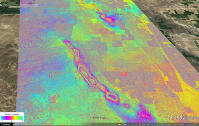
We continue to process repeat-pass browse products and categorize any data acquisition and processing issues as we go.  We came across a repeat observation of Central California separated over 2 years (November 2, 2011 and November 25, 2013) with surprisingly good coherence where we observed ground subsidence as much as 25 cm over the Belridge Oil Field southwest of Lost Hills, California.  The browse interferogram overlaid on Google Earth is attached here showing the ground subsidence over the Oil Field (each color cycle is 12 cm of deformation).

Pages