AirMOSS completed the east coast deployment where three flights were conducted over Duke Forest and three flights over Harvard and Howland Forests. The JSC G-III has since returned to Houston in preparation for the Mexico and MOISST, Oklahoma flights. The team is working to obtain Mexico visas for the flight crew and begin science observations over Chamela, Mexico and MOISST, OK. Science team members from JPL are traveling to Mexico to conduct field sampling at Chamela with the local crew.
You are here
News
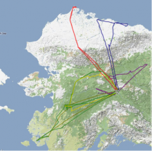
Last week, CARVE flew 29.2 flight hours over Alaska, with flights to Fort Yukon, Barrow, Bethel, Minto, and Huslia
The JPL UAVSAR team briefed NASA's ESD Research and Analysis Program Director, Dr. Jack Kaye, on significant science results based on UAVSAR data. These recent science results covered four disciplines: solid earth deformation, terrestrial hydrology, terrestrial ecology, and levee health. They demonstrated UAVSAR's utility in algorithm validation and calibration for the SMAP mission, mission design trades for the DESDynI mission, and long term monitoring of levee health as well as identifying levee weakness during a flood.
The antenna frame modification was completed and fit checked to verify that the bath tub radome does not interfere with the radar antenna. During weight and balance of the aircraft on June 6, it was determined that the aircraft cannot be balanced with both LVIS and UAVSAR on the aircraft. Dryden's current plan is to remove UAVSAR from the aircraft, get LVIS ready for a range flight next week, and then reinstall UAVSAR on the aircraft with LVIS offloaded. UAVSAR will then conduct a range flight on or around June 27, followed by the NGC-sponsored Canada flight in early July.
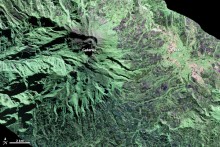
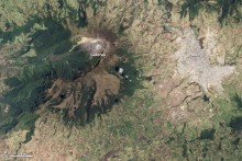
UAVSAR's South America deployment and a polarimetric image of the Galeras volcano in Colombia were featured in NASA Earth Observatory's image of the day
The Dryden G-III is back in service and there are four L-band flights planned for this week, one over the Slumgullion landslide area in Colorado and the other three over the Santa Barbara and Los Angeles Basin area of the San Andreas Fault. The Weather forecast looks good for this week, with no predicted thunderstorms; this should minimize the potential of atmospheric effect distorting small surface deformation signatures in the Repeat Pass Interferometric data products.
The processing team has been busy processing data acquired in South America. Polarimetric data quality has been excellent. Shown below is a polarimetric image of the Uturuncu volcano in Bolivia, the subject of intense international scientific studies. This stratovolcano last erupted more than 300,000 years ago, but the ground surrounding the volcano has been rising 1-2 cm per year since the early 1990s, making it one of the fastest uplifting volcanic areas on the Earth. This volcano will be imaged again next year, and the team will be able to derive the amount of surface deformation from repeat-pass interferometric data products.
Early this week CARVE finished off the May campaign with a flight over Koyukuk and Innoko areas in Alaska. During this flight, CO2 and CH4, were significantly suppressed compared to CARVE flights on May 8 and May 10 over the same areas.
At the end of this flight, CARVE successfully completed the May campaign. CARVE flew nine flights over twelve calendar days for a total of approximately fifty-five science flight hours, covering approximately 8500 miles!
The radar has passed the vibration test and the communication interface test with the GH simulators. The team plans to complete thermal chamber testing by May 19 in order to be certified for flights up to 65,000 ft. Next week, the radar will be ready for installation on the aircraft. The team plans to conduct up to three engineering flights in the first two weeks of June.
UAVSAR completed three L-band flights, two of which were part of the San Andreas Fault monitoring series (Santa Rosa area, area south of Monterey Bay, and Santa Barbara), and the third for Slumgullion landslide monitoring during the snowmelt season. This week the aircraft is out of commission for a few days to address an engine issue. The radar team is also conducting RF ground testing to characterize the RF emission of the radar for the purpose of submitting the NTIA stage 4 spectrum license application (permanent radio frequency transmission license).
The team successfully ported the operational processor to Ames' Pleiades supercomputer after a couple months of troubleshooting the compiler compatibility and multiple test runs. This activity was necessary as Ames shut down the Columbia supercomputer, which UAVSAR had been using for the past three years.
Taking advantage of good weather across Alaska, the CARVE team accumulated ~38 science flight hours the week of May 6. A summary of the flights is below:
- Monday 5/6 – Fort Yukon – Minto Flats – Tanana Flats
- Tuesday 5/7 – Deadhorse – Eastern North Slope
- Wednesday 5/8 – Innoko – Bethel
- Thursday 5/9 – Barrow – Western North Slope
- Friday 5/10 – Koukuk - Innoko


