
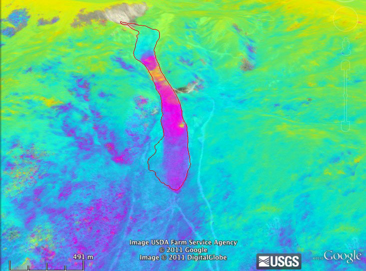
NASA's C-20A (Gulfstream III) Earth science aircraft, carrying a specially designed synthetic aperture radar, recently completed the latest in a series of data collection flights over Colorado's centuries-old Slumgullion landslide. The goal of the research flights, funded by NASA's Science Mission Directorate, is to aid scientists' understanding of the mechanisms controlling landslide motion.
You are here
News
07/16/2012
HyTES, led by Principal Investigator Dr. Simon Hook of NASA’s Jet Propulsion Laboratory, successfully completed its first test flights on board a Twin Otter aircraft flown between Grand Junction, Colorado and Burbank, California the week of July 16, 2012. Initial engineering data were acquired near Grand Junction. Based on an evaluation of those datasets, science datasets were acquired between Grand Junction and Burbank. They include acquisitions over different surface types and gas emissions (sulfur dioxide, methane, ammonia) to determine whether HyTES can be used for gas studies.
07/10/2012
A new ocean story was posted regarding Aquarius detection of the salinity structure associated with tropical instability waves.
(upper) Sea Surface Temperature (SST) and (lower) chlorophyll-a (chl-a) in the eastern Pacific on July 10, 2012. Images created using PO.DAAC’s State of the Ocean (SOTO) Visualization Tool.
 in the eastern Pacific on July 10, 2012.")
 in the eastern Pacific on July 10, 2012 created by SOTO")
06/11/2012
It's been a busy first year in space for Aquarius, NASA's pioneering instrument to measure ocean surface salinity from orbit. Designed to advance our understanding of what changes in the saltiness of the ocean's top layer say about the water cycle and variations in climate, Aquarius took only two and a half months after its launch to start measuring global salinity patterns. Since then, it has also observed regional features such as the freshwater plume gushing from the Amazon River and localized changes in ocean saltiness following a tropical storm. "It was a very remarkable achievement, that within such a short period of time after turning the instrument on we were producing very good-looking data," said Aquarius Principal Investigator Gary Lagerloef, of Earth & Space Research in Seattle. "It was beyond our expectations."

06/07/2012
The C-20A, the military designation of the Gulfstream III business aircraft, is flying from Keflavik International Airport carrying NASA Jet Propulsion Laboratory's Uninhabited Aerial Vehicle Synthetic Aperture Radar (UAVSAR) system mounted in a pod under the aircraft's belly.

06/01/2012
Snowmelt from the Sierra Nevada and the mountains of the Upper Colorado River Basin provides the water upon which Western society is built. In recent years, increases in population and drought have pushed water demand past snowmelt-dominated supply. Climate change and dust deposition from disturbed lands have already begun the encroachment on this precious resource. Drops of lake levels on Lake Mead have threatened unprecedented domestic and international reductions in deliveries and the threat to southern California’s water supply of a seismic breach of levies in the Sacramento-San Joaquin River Delta hangs like the Sword of Damocles. JPL is developing the Airborne Snow Observatory and other systems to bring the nation to a mature monitoring of our snow resource to anchor cutting edge science and water management in an uncertain future.

05/07/2012
QuakeSim co-investigator, Geoffrey Fox gave a plenary talk on "Programming Paradigms for Technical Computing on Clouds and Supercomputers" at the Microsoft Cloud Futures workshop May 7 at UC Berkeley. The QuakeTables fault sets have been imported into GeoServer for display with UAVSAR Repeat Pass Interferometry products on the InSAR Line of Site tool. Users can now specify end points, azimuth, and length of the profile line in additional to drawing the end points on the map. QuakeSim's crustal deformation tools were used to calculate deformation from the Golden Guardian exercise scenario earthquake and aftershock. QuakeSim's disloc was used to calculate the deformation for the 2008 ShakeOut mainshock scenario and an aftershock along the Cucamonga/Sierra Madre fault (rupturing from Cajon Pass to Monrovia in an M 7.2 event. The synthetic interferogram generated from disloc is being used as a layer in the JPL Google Earth API for the response exercise (http://ourocean3.jpl.nasa.gov/qvu/index.php). The displacement output can be used to calculate tilt maps. The E-DECIDER HAZUS kml service is being used in the exercise. It serves up a kml layer that displays the epicenter, faults, and high potential loss facilities from an event.
05/07/2012
Sea surface temperature anomalies (SSTA) in the Eastern Pacific, specifically off the Peruvian coast, have shown a recent warming. SSTA is defined as the difference between the actual temperature and normal conditions for that time of year. Negative anomalies indicate cooler than normal temperatures, while positive anomalies indicate warmer than normal temperatures. Warm anomalies greater than 2°C have been persistent off the northern to central coast of Peru for over one month. Such warming events off Peru have been historically known to precede El Niño conditions in the Equatorial Pacific. Although it is too early to determine whether such warm anomalies will lead to a shift to El Niño conditions in the Equatorial Pacific, some local effects have already been seen.
 in the eastern Pacific on May 7, 2012.")
05/01/2012
The radar team successfully installed one 4.8 m corner reflector on the Rosamond Dry Lake. This corner reflector was imaged by UAVSAR's L-band radar the same evening and a quick look image is shown below, comparing the much stronger return of the 4.8 m reflector to the existing 2.4 m reflector array.

05/01/2012
CARVE is ready for their first science campaign. The first segment is to fly from Fairbanks to CARVE tower, refuel in Bettles, and then take science data over Barrow and return.
