You are here

News

06/01/2017

On May 15, the P-band radar aboard the JSC G-III aircraft embarked on the first of the two ABoVE deployments this year in support of the Arctic-Boreal Vulnerability Experiment (ABoVE) to monitor permafrost active layer thickness, soil moisture, wetland inundation, burned area extent, and forest biomass.  Eight science flights were planned for this deployment, covering study sites in Northwest Territories of Canada and throughout Alaska.

The 117 planned AirMOSS flight lines in Canada and Alaska are shown in the attached maps respectively.  So far we have successfully completed 6 of the 8 flights, including sites near Great Slave Lake, Daring Lake, Delta Junction, Southwest Alaska, Yukon Delta, Denali, and Seward Peninsula.  Both the radar and the aircraft performed well and the polarimetric quick look images showed some amazing landscape all throughout the northern country.  Attached is a polarimetric image of northern Alberta, Canada, showing the different forest types as we traveled southward.

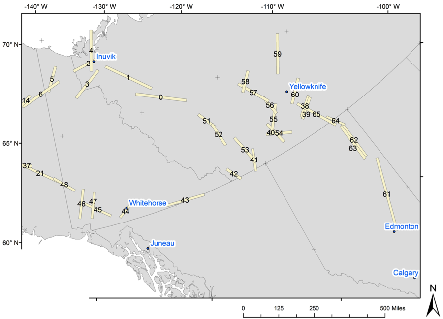
 AirMOSS Radar Coverage in Canada

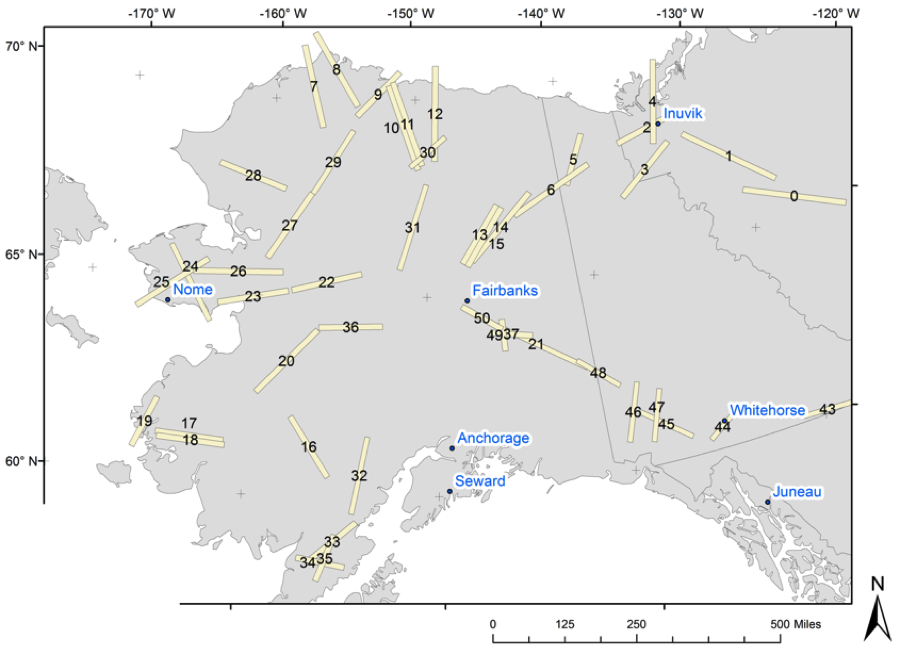
AirMOSS Radar Coverage in Alaska

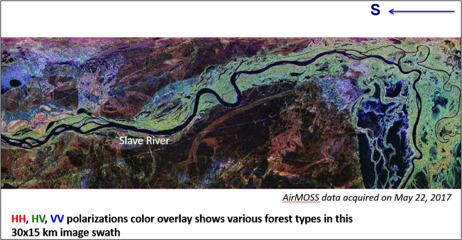
 Quicklook AirMOSS Image of Northern Alberta

05/18/2017

ASO completed its May 1 snow surveys over key basins in the Sierra Nevada including Tuolumne, San Jaoquin, and Merced.  

05/18/2017

On Monday, May 8, the flight team was able to transit from Yap to Palau.  The Palau airport is definitely busier and more accessible than Yap.  However, both Yap and Palau provided great service, even without private aircraft dedicated fixed base operators.

On Wednesday, May 10, the team attempted the sixth Mariana Islands and Palau flight (MIP 06), this time in the afternoon.  The cloud predictions appeared to be better and this afforded an opportunity to show the science team around the aircraft.  In addition, a film crew from HBO’s Vice show filmed the instrument startup procedure.  Twelve lines were collected including overflying the in-water optics team twice.

Favorable weather conditions shifted north, so on Friday, May 12, the team transited back to Guam to prepare for a Northern Mariana Islands flight.

On Saturday, May 13, the seventh flight was attempted (MIP 07), covering reefs around Saipan, Tinian, and Rota.  This was a re-flight with significantly better weather than the prior attempt.  Thirteen lines were collected, although four contained navigation errors.

04/17/2017

ASO completed its April 1 California snow survey flights and successfully delivered data products for the Tuolumne, San Joaquin, Lakes, Lee Vining, and Rush Creek basins.  Fun fact: the sum total snow water equivalent (SWE) for the Tuolumne Basin in 2013, 2014, 2015, and 2016 is 92% of the 2017 snow water equivalent estimate.

03/31/2017

On Monday, March 20, OMG’s mission proceeded using Thule as a deployment base. GLISTIN-A flew 5.7 flight hours acquiring Glacier radar data over Northwestern Greenland.

On Tuesday, March 21, OMG’s mission flew GLISTIN-A 6.1 flight hours from Thule Air base acquiring Glacier radar data over Northeastern Greenland.

On March 22, OMG’s final 2017 GLISTIN-A Greenland science flight flew 4.3 flight hours acquiring radar Glacier data over Northwestern, Greenland. 

03/31/2017

The next generation Airborne Visible and Infrared Imaging Spectrometer (AVIRIS-NG) successfully completed 2 calibration flights under the NOAA Geostationary Operational Environmental Satellite-R Series (GOES-R) Advanced Baseline Imager (ABI).  Flights were conducted on the NASA ER-2 from the Armstrong Palmdale Hangar 703 on March 23 and March 28 over Ivanapah Playa and the Sonoran Desert in Mexico.

03/24/2017

The Ka-band radar aboard the JSC G-III successfully completed the Oceans Melting Greenland mission on Wednesday, March 22.  Altogether, we flew 10 science flights (and one pure transit flight) over a 13-day period from March 10-22 and acquired 85 planned flight lines over the coastal glaciers in Greenland.  We also acquired several opportunistic sea ice lines to cross-check calibration of the processor.  Attached is a quick look DEM (digital elevation model) generated by our deployment team in Greenland over Leidy Gletscher and Marie Gletscher just north of Thule.  

03/24/2017

The next generation Airborne Visible and Infrared Imaging Spectrometer (AVIRIS-ng) is currently supporting the NOAA GOES-R Advanced Baseline Imager Calibration and Validation Campaign. The first flight was conducted on March 21 over the West Coast to image clouds associated with the low pressure system moving across California. 

03/24/2017

GLISTIN-A flew 6.4 flight hours acquiring Glacier radar data over Southeastern Greenland. (Orange track line).  On March 14, OMG’s GLISTIN-A flew 6.2 flight hours acquiring radar Glacier data over OMG Southeastern, Greenland. (Red track line). 

On March 15, OMG’s GLISTIN-A flew 5.3 flight hours and acquired Glacier radar data over the North Eastern, Greenland. (Tan Track line).  

On Friday, March 17, OMG’s GLISTIN-A, flew to the center of Greenland, and acquired radar data at the  “Summit Operational Ice bridge calibration” site, and continued to the South West coast, and finished lines in OMG’s South West Science area.

So Far, OMG’s GLISTIN-A Radar has flown over 46 hours, acquired 57 of 85 planned flight lines, with an accumulation of 2.8 TerraBytes of radar data.

03/10/2017

The Classic Airborne Visible and Infrared Imaging Spectrometer (AVIRIS-C) completed the HyspIRI Hawaii campaign on Friday, March 3.

Pages