
ASO is currently surveying portions of the Klamath National Forest, Shasta-Trinity National Forest, Plumas National Forest, and Lake Tahoe Basin in partnership with the US Forest Service.
You are here
News
06/28/2018
On 21 June, OMG submitted a NASA news release:
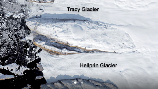
"OMG, the Water's Warm! NASA Study Solves Glacier Puzzle"
https://www.jpl.nasa.gov/news/news.php?release=2018-144
06/28/2018
AVIRIS-NG is flying out of Zurich over target sites for both University of Zurich and the European Space Agency. The instrument has been operating nominally and the campaign has been moving along without any issues. We expect the flights for this year to end around mid-July.
05/24/2018
The Ka-band Glacier and Ice Surface Topography Interferometer (GLISTIN-A) is currently on deployment in Honolulu, HI to study the Kilauea volcano eruption. The objective of this deployment is to use GLISTIN to detect changes in Kilauea’s topography associated with the new lava flows, with the goal of measuring the erupted volume as a function of time and ultimately the total volume of the event. If successful, Principal Investigator Paul Lundgren and his colleagues at USGS plan to use the GLISTIN data to quantitatively evaluate their models for evolution of volcanic processes. Here’s a NASA press release that highlight’s the research effort:
https://www.nasa.gov/feature/help-from-above-nasa-aids-kilauea-disaster-response-1
So far we have imaged the southeastern portion of the Big Island covering Kilauea summit and the east rift zone down to the coast on three different days: May 18, 19, and 21. The data from May 18 & 19 were hand-delivered by Paul Lundgren to JPL on Sunday night where members of the processing team were waiting to start processing the data to determine if the radar has sufficient sensitivity to measure the topography changes associated with new lava flows. Within 24 hours we were able to generate some preliminary amplitude and height products that showed changes due to lava activities from May 18 to May 19.
The current plan is for GLISTIN to remain in Honolulu to make two more observations within the next week as volcano eruption continues to be active.
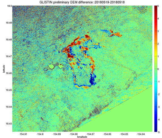
Figure of preliminary GLISTIN height differences (courtesy Paul Lundgren) showing new lava activities in Leilani Estates within the one day period. The color represents height changes in meters. Areas with intense orange and red experienced lava growth of a few meters whereas areas with bluish hue experienced “height loss,” likely due to lava flows toppling trees in the path. This is really good news as we have demonstrated that the GLISTIN radar has sufficient sensitivity to measure topography changes associated with new lava flows! Much work remains to be done to determine if scientists can extract the lava thickness from the DEM (digital elevation model) changes after accounting for tree height changes and measurement noise.
05/24/2018
OMG‘s Airborne eXpendable Conductivity, Temperature, and Depth (AXCTD): Last week, the AXCTD team installed three adjustable attenuators into the distribution amplifier module. With the attenuators installed, cables with the proper length could be ordered. Early next week, the team expects all the required cables to be delivered and final bench testing can be started.
OMG’S GLISTIN-A Radar mission: Last week, OMG’s GLISTIN-A team started processing OMG’s 2018 GLISTIN-A data. Three lines were processed, including Jakboshavn glacier.
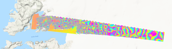
OMG’s GLISTIN-A processed radar data of Jakboshavn glacier from March 2018
The OMG science team is busy reviewing and comparing the 2018 Jakboshavn glacier radar data to previous OMG’s GLISTIN-A Radar data from 2016 and 2017.
05/03/2018
ASO completed April 2018 California snow surveys in the San Joaquin, Tuolumne, Merced, and Kings river basins last week. The ASO team delivered data products for San Joaquin and Tuolumne within one week of completing data acquisition for each basin. The snow depth, snow albedo, and snow water equivalent data from these surveys will be used by California Department of Water Resources and local water agencies to make key water supply decisions for the remainder of the year.
04/06/2018
The Airborne Snow Observatory completed a survey mission 30 March to 1 April to measure water content of snowpack in the Gunnison River basin in southern Colorado. This data will be used by Colorado water resource managers to optimize storage and distribution of water for the upcoming summer months.
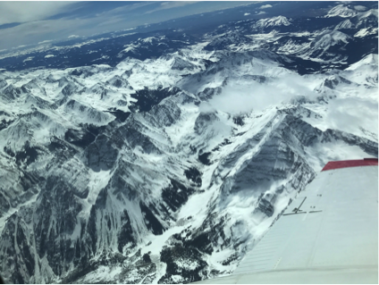
View of the Gunnison Basin from the ASO airplane just south of Aspen, CO
04/01/2018
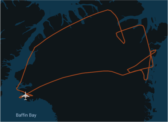
OMG’S GLISTIN-A Radar mission: OMG’s GLISTIN-A team is busy supporting the 2018 GLISTIN-A radar mission. On 19 - 20 March, OMG’s GLISTIN-A radar flew over Western Greenland’s Glaciers from Thule Airforce Base.
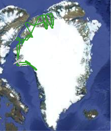
OMG’ North Western science flight track below is from 19 March.
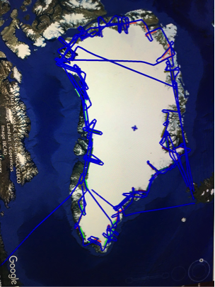
GLISTIN-A concluded 2018 OMG’s science mission on 20 March (Flight track plot shown)
OMG’s 2018 GLISTIN-A mission finished with GLISTIN-A radar, acquiring 84 of 84 science flight lines.
03/22/2018
The Ka-band radar (GLISTIN-A) has successfully completed the Oceans Melting Greenland (OMG) deployment aboard the JSC G-III. Kudos to the aircraft crew and radar team for an excellent job and the mission was completed two days ahead of schedule. In all we acquired 81 science flight lines (100%) and 3 calibration lines over sea ice and preliminary assessment showed the radar data looked good.
03/22/2018
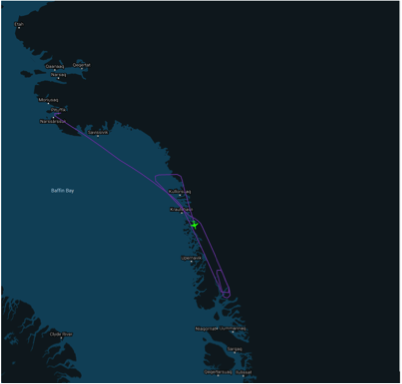
OMG’S GLISTIN-A Radar mission: OMG’s GLISTIN-A team is busy supporting the GLISTIN-A radar mission. On 12 March, OMG’s GLISTIN-A radar flew over Eastern Greenland’s glaciers based from Keflavik, Iceland.
12 March flight track from Iceland
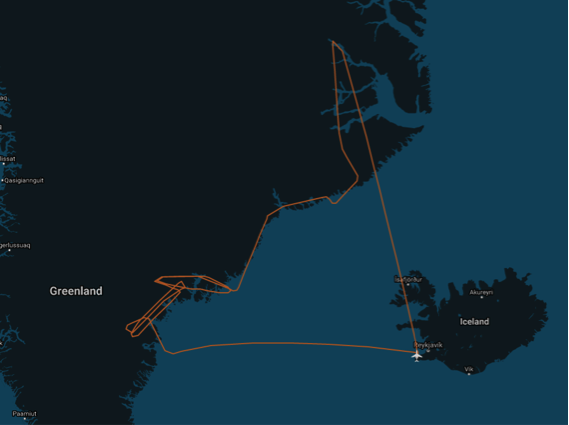
From 12-14 March, GILSITIN continued surveying Eastern Greenland. On 15 March, the G3 flew to Thule Air Force Base, Greenland. On Friday, 16 March, GLISTIN-A radar acquired OMG science data over Eastern and Northern Greenland.
16 March OMG science flight track from Thule Air Force Base