You are here

News

09/20/2018

OMG‘s Airborne eXpendable Conductivity, Temperature, and Depth (AXCTD):  OMG completed the last two flights on 10 & 11 September and flew a total of 15 additional science flight hours. This brings the total number of probes deployed to 239, successfully completing the survey for this year.

OMG science and surveys were featured in a major news article published by Reuters on 19 September:  https://graphics.reuters.com/CLIMATECHANGE-GREENLAND/010080DH0S2/index.html

09/20/2018

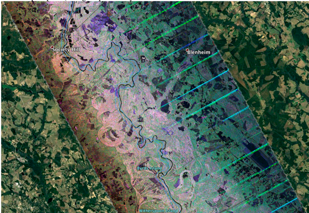
The Ka-band radar aboard the JSC G-III successfully completed a short deployment to Hawaii where we conducted two local science flights to image the Kilauea volcano lava field.  In the mean time, the L-band radar aboard the AFRC C-20A was tasked by FEMA to deploy to the east coast in response to the extensive flooding caused by Hurricane Florence. The aircraft imaged Catawba River (North Carolina) and Pee Dee River (South Carolina) en route to Gainesville, FL on Monday, 17 September.   The attached quicklook polarimetric color composite image of Pee Dee River shows extensive inundation along the river (various shades of pink pixels covering the broad area along the river, 8 to 10 km wide).


UAVSAR HH/HV/VV (RGB) color composite image displayed in Google Earth.
Image swath is ~ 20 km cross track flown in 150 degrees heading looking left.  This
image of Pee Dee River was acquired on 17 September.  Extensive inundation
(various shades of pink pixels) along the present day river and old river
bed across a broad area of 8 to 10 km.

09/06/2018

ASO completed surveys of the Lake Tahoe basin last week in partnership with the US Forest Service. 

Tom Painter, ASO Principal Investigator, was awarded the NASA Exceptional Technology Achievement Medal for the development of the NASA Airborne Snow Observatory, a pioneering platform with unprecedented high resolution measurements of snowpack height and snow water equivalent.

09/06/2018

OMG‘s Airborne eXpendable Conductivity, Temperature, and Depth (AXCTD):  Last week OMG flew a total of 26 flight hours.  OMG deployed AXCTDs from Kulusuk and Constable Point finishing OMG’s Eastern Greenland AXCTD survey. 


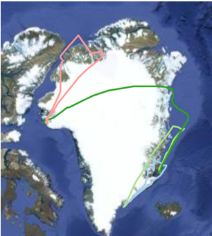
OMG track map showing flights from Kulusuk, Constable Point and Thule Air Force Base.
On Thursday, 30 August, OMG departed Eastern Greenland and landed in Thule Air
Force Base, Western Greenland (Green track line). On Friday, 31 August, OMG flew
North of Thule and dropped 12 AXCTDs, including Ryder and Ostenfield Glaciers.
The sea ice recently pulled away from these Glaciers which is a very rare event (Red track line).


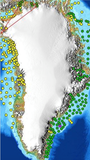
At this point, OMG has dropped 136 AXCTDs probes (green dots).
Next week OMG will start deploying AXCTDs on the west side of Greenland.

OMG’S GLISTIN-A Radar mission:  Last week, OMG’s GLISTIN-A radar team continues working on the final two OMG’s 2018 GLISTIN-A data lines.

08/30/2018

On Wednesday, 22 August, OMG departed Goose Bay, and successfully launched 13 AXCTD probes in South East Greenland and landed at Kulusuk, Greenland.

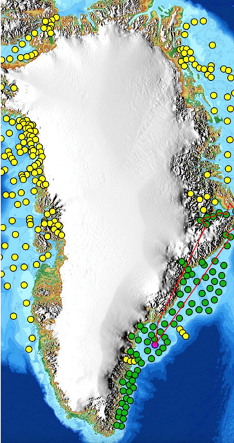
The next two days 23-24 August, OMG deployed 60 AXCTD 60 in South East Greenland. On 25 August, OMG flew north to Scoresby Sound fjords and launched an additional 16 AXCTDs. For the four science flight days, OMG deployed 89 AXCTDS probes!


Map of Greenland shows previous OMG AXCTD drop locations in yellow,
89 successful AXCTD drop locations during 2018 in green, the red line is the Scoresby
flight track, and the Purple dot is the location of an ALAMO float probe deployment.

08/30/2018

ASO is currently surveying Plumas National Forest, Lake Tahoe Basin, and portions of Klamath National Forest and Shasta-Trinity National Forest in partnership with the US Forest Service.

The ASO team, along with partners at the USDA Agricultural Research Service, Bureau of Reclamation, and California Department of Water Resources, were awarded a Bureau of Reclamation John Keys Award last week during the San Joaquin River Restoration Science Meeting.  The recipients of this award are an excellent example of employees, governmental, non-governmental customers that exemplified outstanding business practices, communication, collaboration and partnering achievements that contribute to building and strengthening relationships.

08/30/2018

The Classic AVIRIS (AVIRIS-C) has been flying on the NASA ER-2 as part of the HyspIRI TIR Data collection with HyTES.

08/30/2018

The L-band radar aboard the Armstrong C-20 aircraft is currently on the two-week ABoVE (Arctic-Boreal Vulnerability Experiment) deployment in Fairbanks, AK.  We have successfully completed 6 of the 9 science flights, and both the radar and the aircraft are performing well.


Quicklook polarimetric color composite image of a transect over the
northern edge of Denali National Park.  The radar will return to California
in a few days to complete the San Andreas Fault monitoring flights.

08/23/2018

The Next Generation AVIRIS (AVIRIS-NG) had a successful week of flights in Alaska for the NASA ABoVE campaign.  The 2019 ABoVE campaign is now complete.

The Classic AVIRIS (AVIRIS-C) flew a successful flight over the San Francisco Bay HyspIRI CA Box on Thursday with the NASA ER2. 

07/26/2018

ASO is currently surveying portions of the Klamath National Forest, Shasta-Trinity National Forest, Plumas National Forest, and Lake Tahoe Basin in partnership with the US Forest Service.

Pages