You are here

News

09/29/2020

The SAR-Fusion QUAKES-I side imaging SWIR camera was flown over the northern California LNU Complex, River CZU, and Bobcat fires with the UAVSAR flights on September 3, 9, and 18, 2020 respectively. Optical images were collected out the left window with a full frame camera. The 12.5 km altitude flown for UAVSR and side imaging are useful for situational awareness above the firefighting aircraft. Visible images show the smoke plume while short wavelength infrared (SWIR) imagery sees through the smoke and shows the fire hotspots. An optical science window was installed for the Bobcat fire flight and optical images taken through the plexiglass and optical windows show the improved quality for the optical window.

09/17/2020

Mission Accomplished! OMG completed its flights in Greenland on September 11, 2020. On their final survey day, 22 additional AXCTD probes were dropped which brings the grand total to 321 for the 2020 campaign. They also deployed 3 APEX floats that can return hundreds of profiles and last over a year.

09/09/2020

The L-band radar aboard the AFRC C-20A jet successfully completed the first California wildfire response flight on Thursday, September 3.  We imaged the area north of San Francisco where the LNU Lightning Complex Fire is burning, as well as Oroville Dam site (spillway failure in 2017) and the Camp Fire scar (major fire in 2018, burned the town of Paradise, CA) and Atlas Fire scar (major fire in 2017, burned through Napa and Sonoma Counties).  We had a perfect flight, with no repeat flight lines.  Friday’s California wildfire response flight was scrubbed due to an aircraft maintenance issue (fuel gauge indicator).  This plan will be flown tomorrow (Wednesday, September 9), where we will image fires North of Santa Cruz and the Carmel Fire and River Fire south of Monterey.

Thursday’s data were processed according to the rapid response workflow, where we generated PolSAR products in 24 hours and InSAR products in 48 hours after receipt of raw radar data.  The attached viewgraph shows the LNU and Atlas fire scars in the PolSAR images. The InSAR products are being analyzed by the ARIA team (led by Sang-Ho Yun) to generate Damage Proxy Maps for the National Guard.

09/09/2020

OMG is continuing its campaign in Greenland. They are flying in the eastern Greenland coast, and have dropped a total of 229 AXCTD probes to date.

09/01/2020

OMG was granted a flight release on 8/21/2020 to conduct the campaign in Greenland. The flights will last most of the Month of September, during which they will drop the AXCTD probes. They have dropped 107 probes to date, and are presently flying over the ice sheet to quickly cover the southeast while the weather looks good.

02/12/2020

The L-band radar aboard the JSC G-III is in the midst of the SnowEx campaign, where we have been imaging a dozen instrumented sites in Western U.S. to study the utility of repeat-pass L-band InSAR for monitoring snow water equivalent in several snow climates in California, Idaho, Utah, Colorado, and New Mexico.  We will conduct weekly observations whenever possible through the end of March, then bi-weekly observations through early May.

12/18/2019

We have successfully completed the ISRO L/S-band Airborne SAR (ASAR) Alaska deployment aboard the AFRC C-20A jet.  Thanks to the outstanding flight planning by the JPL and AFRC UAVSAR team and the excellent flight crew support, we were able to conduct 7 flights in 8 days and successfully acquired all but one flight line due to a minor recording issue.  We have now concluded phase 1 science campaign in the US, acquiring L and S-band radar data over glaciers, sea ice, lava flow, landslides, volcanoes, and terrestrial ecology sites, giving ISRO NISAR science team as well as the NASA ASAR science team the data they have requested for algorithm calibration/validation in preparation for the NISAR mission.

10/30/2019

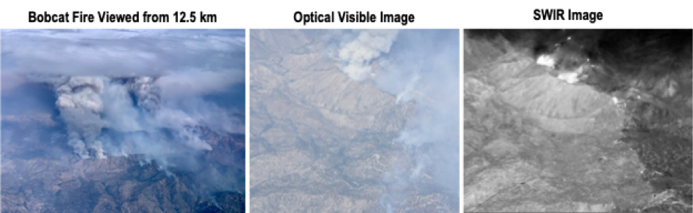
The Airborne Precipitation and cloud Radar 3rd Gen (APR-3) successfully completed the 2019 deployment onboard the NASA P-3 for CAMP2Ex (Clouds Aerosol Monsoon Processes – Philippines Experiment).

The APR-3 has successfully completed the field deployment phase of CAMP2Ex (Clark, Philippines) on board the NASA P-3 from August to October 2019. APR-3 operated successfully in all of the 19 CAMP2Ex science flights.

This field experiment focused on cloud systems ranging from non-precipitating Planetary Boundary Layer cumulus clouds to cumulus congestus on the verge of turning to deep convection, and how they interact with the aerosol and synoptic environment. The latter spanned from monsoonal environment to the outskirts of typhoons, and the resulting systems spanned the whole spectrum of cloud organization. The APR-3 contributed to the experiment by observing at high resolution the three dimensional nature of the individual clouds and convective cells, including their dynamics. Of particular interest are the observations of processes resulting in extremely high precipitation rates despite relatively low vertical cloud development, and those showing the small scale 3-D features of convective processes which directly inform entrainment and detrainment rate estimation as well as convective transport and scavenging. The wide range of cloud and precipitation conditions highlighted the advantages of having all 3 bands, which complement each other, and thus provide jointly a holistic view of these systems where a single one could not.

10/09/2019

On 5 October, ASO collected lidar and imaging spectrometry data for the Merced River Basin to provide an improved snow free baseline dataset for the California Department of Water Resources.  On 7 October, ASO collected lidar and imaging spectrometery data for the Walker Fire are in the Plumas National Forest in Northern California.  At 50,000 acres, the Walker Fire was the largest wildfire in California in 2019.  ASO collected pre-fire data in the same area in fall 2019.  All of these datasets are currently being processed by the ASO team.

Pages